Turkmenistan Flag, Capital and Country Facts
Turkmenistan is located in Central Asia between the Caspian Sea, the Karakum Desert and the mountains on the border with Iran. The green flag contains an unusually detailed carpet pattern. Ashgabat is located on the southern edge of the desert. Historic cities such as Merw and Nisa show that today's dry landlocked state was for a long time integrated into large trade and dominion areas.
Test your knowledge →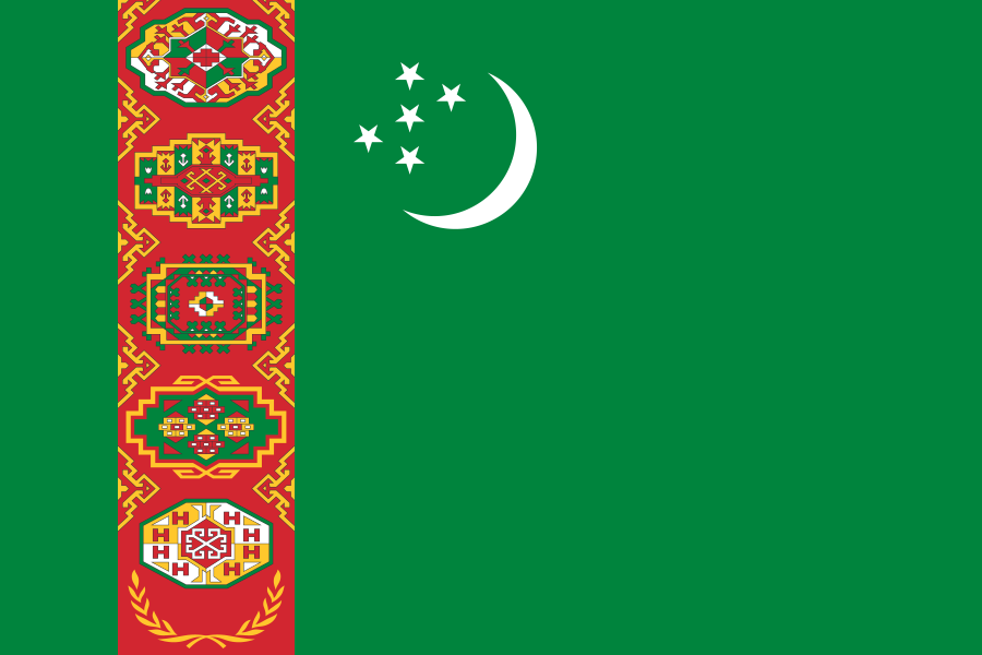
Turkmenistan at a glance
- Capital
- Ashgabat
- Quiz continent
- Asia
- Languages in reference record
- Turkmen; Russian and Uzbek also common
- Currency
- Turkmenistan manate (TMT)
- Population
- 7,618,847 (2025, World Bank)
- Area
- 488,100 km²
- Coastal setting
- Landlocked
- ISO codes
- TM / TKM
- Internet country suffix
- .tm
- Greater desert
- Caracum
- Southern Mountains
- Kopet Dag
- Declaration of Independence
- 27 October 1991
- Today's Independence Day
- 27 September
- Important raw material
- Natural gas
- Large inland waters
- Caspian Sea
Turkmenistan Flag: Design, Meaning and History
The flag has a green field. Near the pole side stands a red vertical ribbon with five carpet medallions arranged one above the other and olive branches crossed underneath. In the upper part of the green area are a white crescent and five white stars. The detailed medallions are the clearest differentiator from other green crescent flags.
The carpet patterns, known as Göls, refer to Turkmen traditions and historical groups. Green and crescent are associated with Islam, the stars with the regions of the country. The olive branches refer to the claim of permanent neutrality. The motif is therefore at the same time a textile cultural reference and a state program; it does not show a single carpet actually spread out.
Capital: Ashgabat
Ashgabat is located near the Kopet-Dag mountain range in the south of the country. Between the edge of the mountains and the desert, the capital developed as an administrative and transport centre. The location explains an important contrast: the wide Karakum characterizes large areas of the state, while larger settlements are often located on better served edges and waterways.
A severe earthquake destroyed large parts of the city in 1948. Subsequent reconstruction and representative new buildings shaped the present appearance. Near Ashgabat are the ruins of Nisa, but the ancient Parthian site and the modern capital are different historical places. Their neighbourhood allows a comparison of different epochs of state power.
Practise this capital →Turkmenistan: Geography, History and Culture
The Karakum occupies a large part of the country. To the west lies the coast of the Caspian Sea, which has no natural access to the ocean. Turkmenistan is therefore a landlocked country despite its coastline. In the south, mountains limit the desert space; water from rivers and canals allows agriculture in otherwise very dry areas. The Amudarja is an important cross-border watercourse in the eastern part of the state area.
Turkmen belongs to the Turkish language family. Carpet manufacturing has a long craftsmanship and cultural significance, which is particularly visible on the flag. Historic mobile ways of life and urban oasis culture are both part of regional history. The present state can therefore neither be explained exclusively by nomadic traditions nor exclusively by monumental capital architecture.
State independence was declared on October 27, 1991. However, today's Independence Day is celebrated on September 27, according to the State Department; this differs from the holiday statement in the factbook archive of 2025. Natural gas is an important economic basis. Older trading sites also remind us that connections with neighbours existed long before modern raw material extraction.
Merw
The historical cultural park of ancient Merw is a UNESCO World Heritage site. It preserves the traces of an important oasis city of ancient trade connections.
Nisa
The Parthian fortresses of Nisa are on the World Heritage List. They document an ancient period of rule in the vicinity of today's capital.
Deserts of Turan
The winter-cold deserts of Turan are a cross-border World Heritage Site. The entry shows that dry landscapes also form independent ecosystems worthy of protection.
Explore neighbouring and related places
 Afghanistan
 Iran
 Kazakhstan
 Uzbekistan
What did you discover?
Sources and image credits
This English article draws on the institutional sources listed below. Figures and memberships retain their stated reference dates.
Source record: 2 November 2026. A translation does not change the reference date of a figure or membership list.
- github.com/factbook/factbook.json/blob/144d6977b2b01ac1cbd220de754c0a005616760b/central-asia/tx.json
- data.worldbank.org/indicator/SP.POP.TOTL
- whc.unesco.org/en/statesparties/tm
- mfa.gov.tm/index.php/en/articles/2
- github.com/mledoze/countries