Malaysia Flag, Capital and Country Facts
Malaysia consists of two large parts of the country, separated by the South China Sea: the Malay Peninsula and the areas of Sabah and Sarawak on Borneo. Kuala Lumpur is the capital, Putrajaya the administrative center of the Confederation. The flag Jalur Gemilang shows fourteen red and white stripes as well as crescent moon and star in a blue corner field.
Test your knowledge →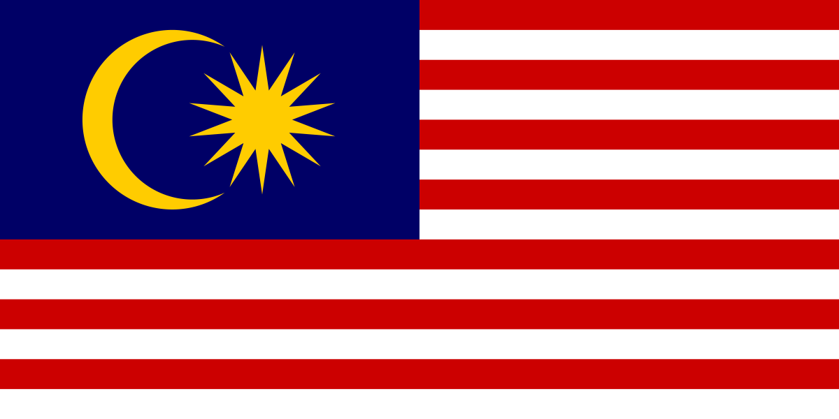
Malaysia at a glance
- Capital
- Kuala Lumpur
- Quiz continent
- Asia
- Languages in reference record
- Malay (Bahasa Malaysia); also inter alia English, Chinese languages, Tamil, Iban and Kadazan Dusun
- Currency
- Malaysian ringgite (MYR)
- Population
- 35,977,838 (2025, World Bank)
- Area
- 330,803 km²
- Coastal setting
- Not landlocked
- ISO codes
- MY / MYS
- Internet country suffix
- .my
- Administrative centre
- Putrajaya’
- Highest point
- Kinabalu, 4.095 m
- Parts of the country on Borneo
- Sabah and Sarawak
- Important strait
- Street of Malacca
- Flag names
- Jalur Gemilang
- States
- Thirteen
Malaysia Flag: Design, Meaning and History
Kuala Lumpur is the capital; Putrajaya is the federal administrative centre.
Fourteen equally high horizontal stripes alternate between red and white. At the top of the mast is a dark blue rectangle with a yellow crescent and a yellow fourteen-pointed star. The crescent moon distinguishes the subject particularly clearly from the US flag, although both work with stripes and a blue corner field.
The flag is called Jalur Gemilang, meaning “glorious stripes”. The fourteen stripes and star-points stand for the thirteen states and the Confederation. The crescent moon refers to Islam, yellow to the monarchical tradition. The design thus depicts political structure and state symbolism; it is not a count of fourteen federal states existing today.
Capital: Kuala Lumpur
Kuala Lumpur is located in the western part of the Malay Peninsula at the confluence of Klang and Gombak. The city name is declared as "sludge estuary" or "sludge confluence". The capital is an important economic and transport centre; its location on the peninsula must not be confused with the Malaysian areas of Borneo.
Putrajaya south of Kuala Lumpur is the administrative centre of the Federal Government. Parliament, on the other hand, is in Kuala Lumpur. The distinction shows why the capital and seat of large parts of the administration do not automatically have to be the same city. In the quiz, the capital answer is Kuala Lumpur; Putrajaya supplements this information with the spatial organization of the state.
Practise this capital →Malaysia: Geography, History and Culture
The Strait of Malacca lies west of the peninsula and forms an important international sea route. East of this, the South China Sea separates the peninsula from Sabah and Sarawak. This division affects distances, transport routes and regional development. Malaysia therefore does not have a continuous land connection between its two major parts of the country, although both belong to the same federation.
On coastal plains, hills and mountains connect. The Kinabalu in Sabah reaches 4,095 meters and is therefore located on Borneo, not near Kuala Lumpur. Tropical forests and karst areas form further defining landscapes. The Kinabalu Park and the Gunung Mulu National Park are both UNESCO natural heritage sites and represent different geological and ecological features of the eastern part of the country.
Malay serves as a national common language, along with English, various Chinese languages, Tamil and many indigenous languages. Trade relations across the seas have long shaped cultural development. The historic cities of Melaka and George Town make this exchange particularly vivid. Their joint UNESCO recognition connects two port cities, whose cityscapes emerged from different economic, political and cultural influences.
Melaka and George Town
The historic cities on the Strait of Malacca became World Heritage in 2008. Their joint entry refers to the international history of maritime trade.
Caves of Niah
The archaeological heritage of the Niah cave complex was added to the World Heritage List in 2024. It complements the trading cities with much older evidence of human presence on Borneo.
Thirteen States and the Federation
The fourteen elements of the flag do not count fourteen states. They include the federal government as an additional common level and are therefore well suited for learning about the federal structure.
Explore neighbouring and related places
 Brunei
 Indonesia
 Thailand
What did you discover?
Sources and image credits
This English article draws on the institutional sources listed below. Figures and memberships retain their stated reference dates.
Source record: 2 November 2026. A translation does not change the reference date of a figure or membership list.
- github.com/factbook/factbook.json/blob/144d6977b2b01ac1cbd220de754c0a005616760b/east-n-southeast-asia/my.json
- data.worldbank.org/indicator/SP.POP.TOTL
- whc.unesco.org/en/statesparties/my/
- github.com/mledoze/countries