Kyrgyzstan Flag, Capital and Country Facts
Kyrgyzstan is a Central Asian high mountain state whose valleys and lakes lie between powerful chains of Tian Shan. Bishkek is located in the northern foreland of these mountains. The flag shows a sun with 40 rays and the umbrella sign of a yurt; an official revision of 2023 changed the shape of the sun's rays.
Test your knowledge →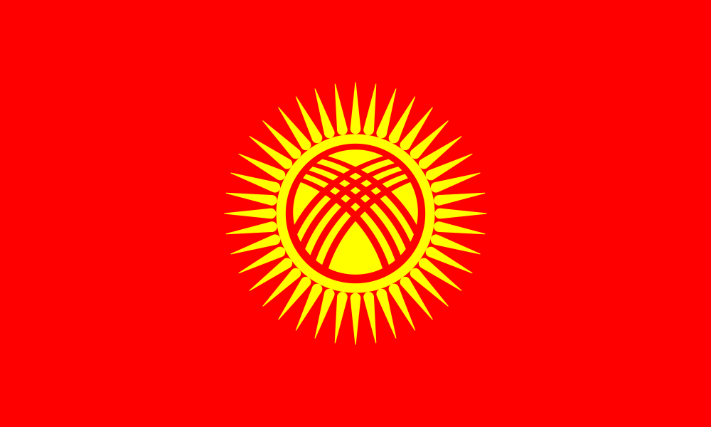
Kyrgyzstan at a glance
- Capital
- Bishkek
- Quiz continent
- Asia
- Languages in reference record
- Kyrgyz (state language) and Russian (official language); also, among others, Uzbek
- Currency
- Kyrgyz Som (KGS)
- Population
- 7,343,064 (2025, World Bank)
- Area
- 199,951 km²
- Coastal setting
- Landlocked
- ISO codes
- KG / KGZ
- Internet country suffix
- .kg
- Highest point
- In Czech Tschokusu, 7.439 m
- Great mountain lake
- Issyk-Kul
- Mountains
- Tian Shan
- Former capital name
- Fruns
- Southern centre
- Osch
- Flag reform
- Solar rays since December 2023
Kyrgyzstan Flag: Design, Meaning and History
A red field carries in the middle a yellow sun with 40 rays. In the solar circle lies the stylized roof opening of a yurt, the Tündük. The crossed lines in the circle distinguish this sign from a simple sun motif. Red and yellow as well as the circular middle sign remain easily recognizable even in small representations.
The 40 rays are related to the Kyrgyz tribal traditions; the Tündük is related to the traditional yurt. At the end of 2023, the design was officially revised: Sun rays replaced the older wave-shaped version. Older illustrations can therefore look different, although the basic color, sun motif and roof sign remain the same. This is a graphical change within the same symbol structure.
Capital: Bishkek
Bishkek is located in the north of the Chuital near the border with Kazakhstan. The capital is thus not in the middle of the highest mountain core, but in a comparatively accessible basin on the edge of the mountains. This situation explains their transport links to the northern neighbouring regions and their role as a political and economic centre.
The city was called Frunze for much of the Soviet period; the name Bishkek was reintroduced in 1991. Osch in the south forms another important center with a different historical and geographical integration. Between the northern and southern settlement areas are high mountains, so short distances on the map do not guarantee easy traffic routes.
Practise this capital →Kyrgyzstan: Geography, History and Culture
The Tian Shan and its valleys shape almost the entire country. Dzhengisch Tschokusu, also known as Pik Pobedy, reaches 7,439 meters. In between are basins with lakes and agricultural land. The altitude influences vegetation, pasture and seasons; the difference between valley soil and high pasture may be more important than a uniform climate indication for the entire state.
Issyk-Kul is located in a large mountain basin in the northeast. It is a particularly striking map feature and helps with the orientation between Bishkek and the eastern high mountains. Kyrgyzstan has no maritime access and borders Kazakhstan, Uzbekistan, Tajikistan and China. Mountain passes structure both internal connections and exchange across state borders.
Kyrgyzstan is the state language, Russian also has an official status. Other languages are also spoken, including Uzbek. The yurt on the flag refers to mobile ways of life and economy, but does not describe the everyday life of all people in today's country. Cities, irrigated valleys and high pastures are equally part of the social and economic landscape.
Sulaiman-Too in Osch
The sacred mountain became a World Heritage Site in 2009. It combines southern city history with religious traditions and complements the focus on Bishkek.
Silk Roads in Tian Shan
Kyrgyz sites are part of the cross-border UNESCO entry of the Chang’an–Tian Shan Corridor. Historical connections thus followed certain routes through the mountains, not a single straight highway.
Western Tian Shan
The cross-border natural heritage was added in 2016. It makes it clear that mountain ecosystems extend beyond today’s national borders.
Explore neighbouring and related places
 China
 Kazakhstan
 Tajikistan
 Uzbekistan
What did you discover?
Sources and image credits
This English article draws on the institutional sources listed below. Figures and memberships retain their stated reference dates.
Source record: 2 November 2026. A translation does not change the reference date of a figure or membership list.
- github.com/factbook/factbook.json/blob/144d6977b2b01ac1cbd220de754c0a005616760b/central-asia/kg.json
- data.worldbank.org/indicator/SP.POP.TOTL
- president.kg/ru/about/symbol
- whc.unesco.org/en/statesparties/kg/
- github.com/mledoze/countries