Kenya Flag, Capital and Country Facts
Kenya lies on the equator in East Africa, ranging from the Indian Ocean coast to the highlands, lakes and dry northern regions. Nairobi is located inland. The name of the country is reminiscent of Mount Kenya, whose high alpine peaks show that equator proximity and tropical warmth do not mean the same conditions everywhere.
Test your knowledge →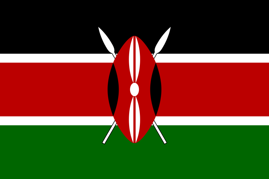
Kenya at a glance
- Capital
- Nairobi
- Quiz continent
- Africa
- Languages in reference record
- Swahili and English; numerous other languages
- Currency
- Kenya shilling (KES)
- Population
- 57,532,493 (2025, World Bank)
- Area
- 580,367 km²
- Coastal setting
- Not landlocked
- ISO codes
- KE / KEN
- Internet country suffix
- .ke
- Highest mountain
- Mount Kenya, 5,199 m
- Independence
- 12 December 1963
- Great rift quarry
- East African Rift
- UNESCO coastal city
- Lamu
- Great northern lake
- Lake Turkana
- Coastal town
- Mombasa
Kenya Flag: Design, Meaning and History
Three broad horizontal stripes in black, red and green are separated by narrow white lines. In the middle are a traditional shield and two crossed spears. The shield covers parts of the stripes and makes the flag clearly distinguishable from other black-red-green tricolors.
The colors are associated with population, independence struggle and natural resources; white stands for peace. Shield and spears refer to the defense of freedom. The motif uses a form based on Maasai shields, but should not be understood as a representation of a single culture that is uniform for the entire country.
Capital: Nairobi
Nairobi is located in the southern highlands and thus significantly higher than the coastal city of Mombasa. The capital was created as an important place on the railway connection inland. Its location explains why Kenya’s political and economic center today is not directly on the Indian Ocean, although maritime trade relations are part of the country’s history.
The name Nairobi is derived from a Maasai expression for cool water. The altitude matches this fact: the climate differs from the hotter coastal lowlands. At the same time, the capital must not be equated with the nearby national park; the city and the protected area are different, closely neighboring spaces.
Practise this capital →Kenya: Geography, History and Culture
The East African Rift runs through the country and contributes to its varied relief. Highlands and lakes stand alongside savannahs and dry landscapes. Mount Kenya reaches 5,199 meters and is one of the highest mountains in Africa after Kilimanjaro. Its mountain ecology differs greatly from the plain at the foot of the massif.
The UNESCO lakes in the Rift Valley and Lake Turkana open up further natural stories. Lakes can have very different properties due to geological basins, different water supply and evaporation. Kenya’s coastal area complements these inland landscapes with coral and marine spaces; the national natural diversity is therefore much broader than the common image of a single savannah landscape.
Swahili and English are official languages. Numerous other languages reflect the diversity of population groups. On the coast, the old town of Lamu documents the long history of Swahili culture and trade in the Indian Ocean. This urban heritage complements the natural sites and connects Kenya with maritime exchange relations.
Lamu as a coastal city
The UNESCO Old Town preserves an important testimony of Swahili culture. Its construction and trade history makes it clear that Kenya, in addition to inland highlands and wildlife, also has its own coastal and urban history, which is connected to the Indian Ocean.
Mount Kenya on the Equator
The height of the mountain creates alpine habitats in an equatorial location. This is a particularly vivid example of how elevation strongly affects temperature and geographic latitude alone is not enough to describe a local climate.
Rift Valley and Lakes
The trench quarry combines geological development with today's landscape. The lake landscapes help to spatially divide Kenya; they are not independent decorations on the map, but part of a larger East African system.
Explore neighbouring and related places
 Ethiopia
 Somalia
 South Sudan
 Tanzania
 Uganda
What did you discover?
Sources and image credits
This English article draws on the institutional sources listed below. Figures and memberships retain their stated reference dates.
Source record: 2 November 2026. A translation does not change the reference date of a figure or membership list.
- github.com/factbook/factbook.json/blob/144d6977b2b01ac1cbd220de754c0a005616760b/africa/ke.json
- data.worldbank.org/indicator/SP.POP.TOTL
- whc.unesco.org/en/statesparties/ke/
- github.com/mledoze/countries