Somalia Flag, Capital and Country Facts
Somalia lies on the Horn of Africa between the Gulf of Aden and the Indian Ocean. Long coasts, dry highlands and the rivers in the south characterize very different habitats. The light blue flag carries a single white star. Mogadishu is the capital and historical port city in a region of the Indian Ocean that has been interconnected for centuries.
Test your knowledge →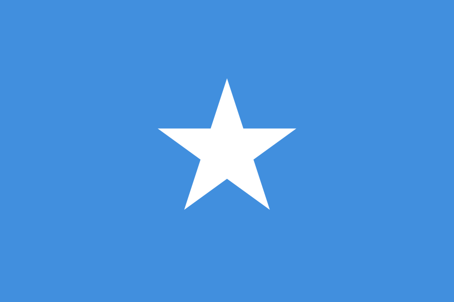
Somalia at a glance
- Capital
- Mogadishu
- Quiz continent
- Africa
- Languages in reference record
- Somali and Arabic
- Currency
- Somalia shilling (SOS)
- Population
- 19,654,739 (2025, World Bank)
- Area
- 637,657 km²
- Coastal setting
- Not landlocked
- ISO codes
- SO / SOM
- Internet country suffix
- .so
- Highest mountain
- Shimbiris, archive value 2,460 m
- Establishment of the State
- 1 July 1960
- Northern sea area
- Gulf of Aden
- Important river
- Jubba
- Further river
- Shabelle
- Flag star
- Five points
Somalia Flag: Design, Meaning and History
The flag shows a large white five-pointed star in the middle on a light blue background. Additional stripes, coats of arms or inscriptions are missing. The simple surface layout distinguishes them from other blue-white flags with several stars or a cross. The five star tips can be seen as a coherent central sign.
The flag was created in 1954 before independence. Blue was also originally influenced by the environment of the United Nations; later it is also associated with sky and sea. The five peaks are reminiscent of historical settlement spaces of Somali populations in several present-day states. This historical symbolism must not be read as a description of the internationally recognized state borders.
Capital: Mogadishu
Mogadishu is located on the coast of the Indian Ocean. The capital was involved in maritime trade and Islamic networks long before the modern founding of the state. Its location connects the African hinterland with routes to Arabia and further across the ocean. The history of the city therefore does not begin with European colonial rule.
Civil war and political violence have severely affected the city and infrastructure. At the same time, there is everyday economic life and reconstruction. A description must neither hide this damage nor reduce the population to experiences of conflict. The Secondo Lido lighthouse is on the UNESCO list of proposals; it reminds of the maritime city history, without being already inscribed World Heritage.
Practise this capital →Somalia: Geography, History and Culture
Large parts of the country are dry to semi-arid. Mountains rise in the north, while in the south Jubba and Shabelle are particularly important for agriculture and settlements. Precipitation fluctuates greatly, so droughts and floods can hit different regions. A long coastline does not mean that enough fresh water is available inside.
Somali is a Kushite language, Arabic another official language. Livestock farming and trade relations have shaped many communities, but not all people live pastorally. Cities, agriculture and widely scattered diaspora connections also belong to the countryside. Such different ways of life are concrete adaptations to history and environment, not immutable cultural characteristics.
In 1960, the previously British and Italian administered territories united into a republic. Somaliland in the north has declared itself independent since 1991 and has its own institutions; its international status remains controversial. The United Nations stresses Somalia’s territorial integrity. The factbook archive status of 2025 is therefore not adopted as an unchanged description of every current diplomatic development.
Two coastal zones
To the north is the Gulf of Aden, to the east is the Indian Ocean. The situation in the Horn of Africa connects Somalia with important international shipping routes.
Jubba and Shabelle
The two rivers distinguish the south from the drier parts of the country. Their water supply also depends on precipitation in the above catchment areas.
UNESCO list of proposals
Bushbushle and the grass and bush landscape near Hobyo are on the list of proposals. This earmarking must be distinguished from a recording as a World Heritage Site.
Explore neighbouring and related places
 Djibouti
 Ethiopia
 Kenya
What did you discover?
Sources and image credits
This English article draws on the institutional sources listed below. Figures and memberships retain their stated reference dates.
Source record: 2 November 2026. A translation does not change the reference date of a figure or membership list.
- github.com/factbook/factbook.json/blob/144d6977b2b01ac1cbd220de754c0a005616760b/africa/so.json
- data.worldbank.org/indicator/SP.POP.TOTL
- whc.unesco.org/en/statesparties/so
- dppa.un.org/en/speeches-and-statements/asg-khiari-warns-security-council-of-regional-risks-following-israels
- github.com/mledoze/countries