Guatemala Flag, Capital and Country Facts
Guatemala connects volcanic highlands with tropical lowlands and coasts to the Pacific and Caribbean. Particularly important is the history of the Maya, which shows itself both in archaeological cities and in languages spoken today. The modern capital Guatemala City is located in the highlands; Antigua Guatemala and Tikal open up other spatial and historical focal points.
Test your knowledge →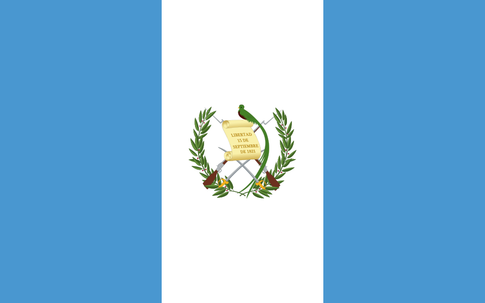
Guatemala at a glance
- Capital
- Guatemala City
- Quiz continent
- North America
- Languages in reference record
- Spanish; numerous Mayan languages as well as Xinka and Garífuna
- Currency
- Guatemalan Quetzal (GTQ)
- Population
- 18,687,881 (2025, World Bank)
- Area
- 108,889 km²
- Coastal setting
- Not landlocked
- ISO codes
- GT / GTM
- Internet country suffix
- .gt
- Highest mountain
- Tajumulco, 4,220 m
- National bird
- Quetzal
- Former capital
- Antigua Guatemala
- Mayan sites
- Tikal
- Northern lowlands
- Petén
- Independence from Spain
- 15 September 1821
Guatemala Flag: Design, Meaning and History
Three equally wide vertical stripes are light blue, white and light blue. In the middle is the state coat of arms. In it, a Quetzal sits over a scroll; crossed weapons and a laurel wreath complement the motif. The vertical stripe direction distinguishes Guatemala from several horizontal blue-white-blue striped flags of Central America.
The blue areas are connected to the Pacific and Caribbean, white with peace. The scroll commemorates September 15, 1821, the date of independence from Spain. The Quetzal is at the same time a national bird and namesake of the currency; a single motif combines flag, wildlife, history and daily means of payment.
Capital: Guatemala City
Guatemala City is located in the southern highlands and forms the political center. The state name and the city name are closely connected, but Guatemala designates the whole country. In German, the addition city prevents a misunderstanding, especially if at the same time it is spoken of historical places like Antigua Guatemala.
Antigua was a former capital and was replaced by the present site after severe earthquake damage in the 18th century. UNESCO protects its historical cityscape. The comparison makes the importance of natural hazards clear: the history of the capital is closely linked to earthquakes and the handling of a volcanic habitat.
Practise this capital →Guatemala: Geography, History and Culture
In the west and south, mountain ranges and volcanoes rise. Tajumulco reaches 4,220 meters and is the highest mountain in Central America. North of it are the vast lowlands of Petén. The differences in elevation produce very different climatic conditions; a tropical country does not have the same temperatures or the same vegetation everywhere.
Tikal is located in the northern lowlands and connects important Mayan buildings with tropical forest. UNESCO manages the National Park as a mixed cultural and natural heritage. Monumental temples and their surroundings can therefore be viewed together: the preserved buildings stand within an ecosystem that is essential for the protection of the entire site.
In addition to Spanish, numerous Mayan languages are spoken. The present of the Maya should therefore not be reduced to archaeological past. Names, languages, local traditions and communities continue to form a part of the country. Different settlement areas in the highlands and lowlands also explain why a single cultural image can represent Guatemala only incompletely.
Quetzal on several levels
The bird appears in the coat of arms on the flag and gives the currency its name. This connection is particularly learning-friendly: Anyone who recognizes the Quetzal can associate the same word with nature, state signs and the means of payment of Guatemala.
Tikal in the forest
The UNESCO heritage protects both archaeological monuments and their natural environment. It is precisely this double classification that distinguishes Tikal from pure urban monuments and makes the place an example of the connection between settlement history and tropical ecology.
A former capital
Antigua Guatemala preserves numerous testimonies of colonial building history. The relocation of the capital explains why today a historical place and a modern political center perform different tasks, even though both belong closely to the history of the same state.
Explore neighbouring and related places
 Belize
 El Salvador
 Honduras
 Mexico
What did you discover?
Sources and image credits
This English article draws on the institutional sources listed below. Figures and memberships retain their stated reference dates.
Source record: 2 November 2026. A translation does not change the reference date of a figure or membership list.
- github.com/factbook/factbook.json/blob/144d6977b2b01ac1cbd220de754c0a005616760b/central-america-n-caribbean/gt.json
- data.worldbank.org/indicator/SP.POP.TOTL
- whc.unesco.org/en/statesparties/gt/
- github.com/mledoze/countries