Mexico Flag, Capital and Country Facts
Mexico connects North America with the Central American Land Bridge and has coastlines on the Pacific, Gulf of Mexico and the Caribbean. Deserts in the north, high mountains and tropical southern regions stand side by side. Mexico City is located high inland on the territory of an older sea and settlement area, whose history dates back to Tenochtitlán.
Test your knowledge →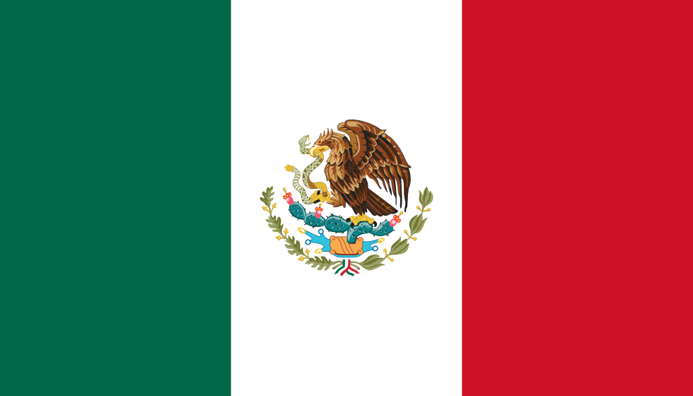
Mexico at a glance
- Capital
- Mexico City
- Quiz continent
- North America
- Languages in reference record
- Spanish and numerous indigenous national languages, including Nahuatl and Mayan languages
- Currency
- Mexican peso (MXN)
- Population
- 131,946,900 (2025, World Bank)
- Area
- 1,964,375 km²
- Coastal setting
- Not landlocked
- ISO codes
- MX / MEX
- Internet country suffix
- .mx
- Highest mountain
- Pico de Orizaba, 5,636 m according to the archives
- Historic capital
- Tenochtitlán
- Northwestern Peninsula
- Baja di Calabria
- Southeastern Peninsula
- Yucatán
- National holiday
- 16 September
- UNESCO water landscape
- Xochimilco
Mexico Flag: Design, Meaning and History
The flag shows three equally wide vertical stripes in green, white and red. In the white middle strip stands the state coat of arms with eagle, snake and cactus. The coat of arms is the most important distinguishing feature from the similarly colored Italian tricolor, whose white center remains in the usual national flag without this motif.
The eagle sits on a cactus holding a snake. The picture takes up the founding narrative of Mexico, which is connected to Tenochtitlán. As a historical tradition, this narrative explains the choice of the state sign; it should not be presented as a scientifically documented founding process. The motif combines modern statehood with pre-Spanish history.
Capital: Mexico City
Mexico City is located in a high-altitude basin inland. The modern capital overlays the historic Tenochtitlán, which once lay in a lake landscape. This makes today’s city a place of profound environmental change: the history of water is just as much part of its understanding as streets, squares and administrative buildings.
The historic center and Xochimilco are jointly part of the UNESCO World Heritage. While the center preserves important buildings of different eras, Xochimilco with canals and traditional cultivation areas reminds of the older lake landscape. Both parts show that capital history consists not only of monuments, but also of the redesign and use of a special natural space.
Practise this capital →Mexico: Geography, History and Culture
Mountain ranges divide Mexico and enclose vast highlands. The Pico de Orizaba reaches 5,636 meters according to the Factbook archive. In the north are dry landscapes, in the south and southeast more humid tropical spaces. High altitude and latitude work together; a country with a tropical share can therefore simultaneously possess cold high mountain areas and dry deserts.
The peninsulas of Baja California in the northwest and Yucatán in the southeast give Mexico a striking shape. Baja California is located between the Pacific and the Gulf of California, Yucatán separates the Gulf of Mexico from the Caribbean. The two similarly known peninsulas belong to different coastal areas and should not be confused on the map.
Spanish is the most important nationwide linguistic language; numerous indigenous languages are recognized as national languages. Mayan sites such as Chichén Itzá and other historical centers are part of a diverse cultural heritage. The pre-Hispanic history spans different societies and epochs, so Maya, Mexico and other groups should not be used as interchangeable names.
Coat of arms and founding narrative
Eagles, snake and cactus connect the flag with the traditional foundation of Tenochtitlán. The motif provides a precise reminder and distinguishes Mexico from Italy, even if the three stripes seem similar at first glance.
Xochimilco's aquatic landscape
Canals and traditional cultivated areas preserve part of the former lake landscape of the capital basin. The UNESCO ensemble not only protects architecture, but also provides evidence of a special interaction between water, agriculture and settlements.
Two large peninsulas
Baja California and Yucatán frame very different sea spaces. If you know their location, Mexico’s coasts can be arranged much better and the differences between the Pacific, the Gulf of Mexico and the Caribbean can be traced on a map.
Explore neighbouring and related places
 Belize
 Guatemala
 United States
What did you discover?
Sources and image credits
This English article draws on the institutional sources listed below. Figures and memberships retain their stated reference dates.
Source record: 2 November 2026. A translation does not change the reference date of a figure or membership list.
- github.com/factbook/factbook.json/blob/144d6977b2b01ac1cbd220de754c0a005616760b/north-america/mx.json
- data.worldbank.org/indicator/SP.POP.TOTL
- whc.unesco.org/en/statesparties/mx/
- github.com/mledoze/countries