Honduras Flag, Capital and Country Facts
Honduras is located in Central America between Guatemala, El Salvador and Nicaragua. A long Caribbean coast faces a small Pacific access on the Gulf of Fonseca. The five stars of his flag are reminiscent of a former Central American Federation. Mountain ranges, Mayan sites and the forests on the Mosquito Coast show different sides of the country.
Test your knowledge →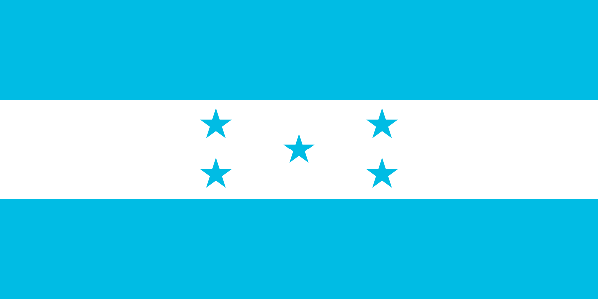
Honduras at a glance
- Capital
- Tegucigalpa
- Quiz continent
- North America
- Languages in reference record
- Spanish; other languages including Garífuna and Miskito
- Currency
- Lempira (HNL)
- Population
- 11,005,850 (2025, World Bank)
- Area
- 112,492 km²
- Coastal setting
- Not landlocked
- ISO codes
- HN / HND
- Internet country suffix
- .hn
- Highest mountain
- Cerro Las Minas, 2,870 m
- Independence Day
- 15 September 1821
- Capital district
- Distrito Central
- Pacific access
- Gulf of Fonseca
- Mayan sites
- Copán
- Name of the currency
- Lempira
Honduras Flag: Design, Meaning and History
Three equally wide horizontal stripes are blue, white and blue. In the white field are five blue stars in a cross-like X-arrangement: one in the middle and four around it. Coats of arms or writing are missing. The stars help distinguish Honduras from similar blue-white-blue flags of other Central American states.
The five stars are reminiscent of Costa Rica, El Salvador, Guatemala, Honduras and Nicaragua as members of the former Central American Federation. Blue is associated with Pacific and Caribbean, white with peace. Historical representations used different shades of blue. For the quiz, stripe sequence and five stars are therefore more reliable features than an impression of particularly light or dark blue.
Capital: Tegucigalpa
Tegucigalpa is the capital used in the quiz. In constitutional law, Tegucigalpa and Comayagüela together form the capital in the Distrito Central. The two urban areas are located on the Choluteca and are closely connected. This peculiarity explains why other reference works occasionally give both names, although Tegucigalpa remains the common short answer.
The city developed in a mountainous region with historical mining. The relief influences traffic routes and buildings more than on a flat coast. The contrast with the Caribbean coast is clear: the capital and administration are located inside, while port, island and rainforest areas have other economic and ecological priorities.
Practise this capital →Honduras: Geography, History and Culture
Mountains and highlands occupy large parts of Honduras. The Cerro Las Minas reaches 2,870 meters. In addition to a tropical location, the climate is strongly influenced by altitude and precipitation. The eastern lowlands of the Moskitia are significantly differently shaped and developed than the western highland regions. The Caribbean side also includes the Islas de la Bahía. The islands extend the state’s landscape beyond its predominantly mountainous mainland area and explain part of its maritime connections.
Spanish is an official language. Garífuna, Miskito and other communities have their own linguistic and cultural traditions. This diversity should not disappear into a single image of a Spanish-speaking population. The history of the Maya also belongs to the country, although large parts of today's population have other regional and historical references.
Honduras became independent from Spain in 1821 and later belonged to the Central American Federation. In the factbook archive stand of 2025, agriculture, clothing production and international remittances are part of the economic structure. For geography, the difference between the long Caribbean coast and the narrow Pacific access is particularly helpful: The state is located on two sea spaces, but not in a symmetrical position.
Copán
The Mayan site of Copán is a UNESCO World Heritage site. Their buildings and pictorial works document an important pre-Columbian urban history in the west of the country.
River Plátano
The Río Plátano Biosphere Reserve is a World Heritage Site. It protects a significant section of the eastern forest and river landscapes.
Gulf of Fonseca
Honduras has access to the Pacific and shares the Gulf with El Salvador and Nicaragua. The short coastline complements the much longer Caribbean coastal area.
Explore neighbouring and related places
 Guatemala
 El Salvador
 Nicaragua
What did you discover?
Sources and image credits
This English article draws on the institutional sources listed below. Figures and memberships retain their stated reference dates.
Source record: 2 November 2026. A translation does not change the reference date of a figure or membership list.
- github.com/factbook/factbook.json/blob/144d6977b2b01ac1cbd220de754c0a005616760b/central-america-n-caribbean/ho.json
- data.worldbank.org/indicator/SP.POP.TOTL
- whc.unesco.org/en/statesparties/hn
- github.com/mledoze/countries