Belgium Flag, Capital and Country Facts
Belgium is located on the North Sea between France, the Netherlands, Germany and Luxembourg. Its small area includes coastal plains, densely networked cities and the forested heights of the Ardennes. Languages and regional responsibilities shape the state just as clearly as Brussels, whose international role extends far beyond Belgium.
Test your knowledge →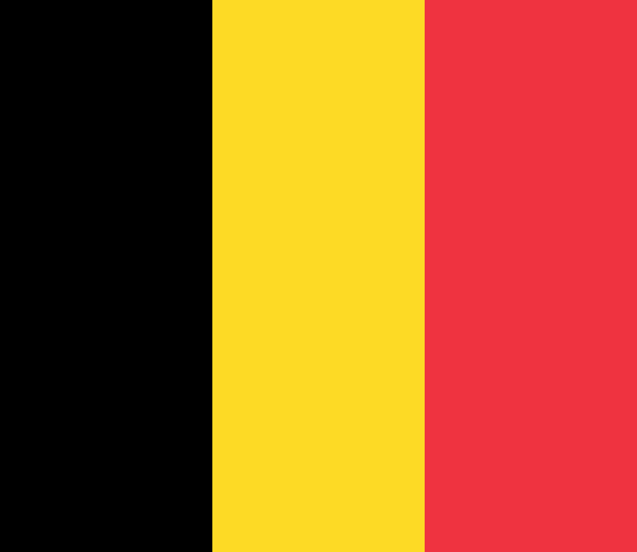
Belgium at a glance
- Capital
- Brussels
- Quiz continent
- Europe
- Languages in reference record
- Dutch, French and German
- Currency
- Euro (EUR)
- Population
- 11,941,781 (2025, World Bank)
- Area
- 30,528 km²
- Coastal setting
- Not landlocked
- ISO codes
- BE / BEL
- Internet country suffix
- .be
- Highest point
- Botrange, 694 m
- National holiday
- 21 July
- Historical coat of arms
- Lion of Brabant
- Coastal
- North Sea
- Southeastern landscape
- Ardennes and High Venn
- UNESCO City Ensemble
- Grand Place in Brussels
Belgium Flag: Design, Meaning and History
The Belgian flag consists of three vertical stripes in black, yellow and red. Black is on the mast, red on the outer edge. The vertical arrangement is crucial: Germany uses a horizontal tricolor and also has a different order, namely black, red and gold.
The colors go back to the coat of arms of the Duchy of Brabant: a golden lion with red features on a black background. The shape of the tricolor was based on the French model. Thus, the flag combines a regional coat of arms tradition with the political departure to Belgian independence in the 19th century.
Capital: Brussels
Brussels is the capital of Belgium and at the same time the centre of its own capital region. In this region, French and Dutch are official languages. The capital is therefore not a simple representative of only one of the two major linguistic regions, but has a special position within the Belgian state order.
The Grand-Place shows the older commercial and city history of Brussels. Around the square stand the town hall and representative guild houses; UNESCO runs the ensemble as a world heritage site. In addition to this historic city level, Brussels is known through European institutions, which bring together national and international functions spatially.
Practise this capital →Belgium: Geography, History and Culture
The shallow North Sea coast merges inland into hill country. In the southeast, the Ardennes and the High Venn reach greater heights; the botrange is the highest point in the country. The relief explains why, despite the short distances, the southeastern landscapes look different than the coastal plain in the northwest.
Belgium has three official languages and several levels of territorial and linguistic organisation. Dutch is spoken mainly in Flanders, French mainly in Wallonia and Brussels. The German-speaking community is located in the east. The linguistic community and the region denote different types of political competence, which should not simply be equated.
Historic commercial cities, canals and transport routes connect Belgium closely with its neighbours. Bruges, Antwerp, Ghent and Brussels represent different chapters of this city’s history. The fact that the country borders the North Sea remains important for trade and ports, even though many of its most famous political and cultural places are inland.
Grand Place in Brussels
UNESCO Square combines different architectural styles to form an urban ensemble. Town Hall and guild houses tell of communal power and economic unions; the square is therefore more than a collection of particularly richly decorated facades.
Three languages
The German-speaking population forms a small group in numbers, but their language still has official status. Belgium is thus particularly vivid in showing that the legal recognition of a language does not depend solely on its national distribution.
From the sea to the highland
There are very different landscapes between the North Sea coast and the Botrange. The highest point reaches 694 meters: not a high mountain, but a clear contrast to the flat coast and an important landmark for southeastern Belgium.
Explore neighbouring and related places
 France
 Germany
 Luxembourg
 Netherlands
What did you discover?
Sources and image credits
This English article draws on the institutional sources listed below. Figures and memberships retain their stated reference dates.
Source record: 2 November 2026. A translation does not change the reference date of a figure or membership list.
- github.com/factbook/factbook.json/blob/144d6977b2b01ac1cbd220de754c0a005616760b/europe/be.json
- data.worldbank.org/indicator/SP.POP.TOTL
- whc.unesco.org/en/list/857/
- github.com/mledoze/countries