Luxembourg Flag, Capital and Country Facts
Luxembourg is a small landlocked country between Belgium, Germany and France. The capital bears the same name as the country and is characterized by deep valleys and former fortifications. In the north extends the hilly Ösling, in the south the more populated estate; the Moselle forms an important eastern border area.
Test your knowledge →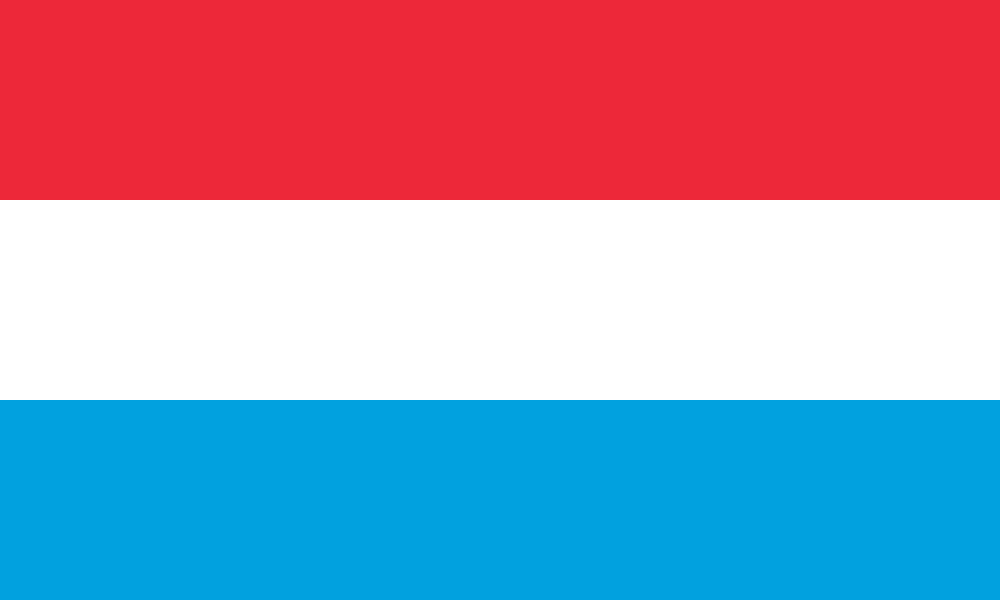
Luxembourg at a glance
- Capital
- Luxembourg City
- Quiz continent
- Europe
- Languages in reference record
- Luxembourgish, French and German with different legal functions
- Currency
- Euro (EUR)
- Population
- 686,970 (2025, World Bank)
- Area
- 2,586 km²
- Coastal setting
- Landlocked
- ISO codes
- LU / LUX
- Internet country suffix
- .lu
- Designation of State
- Grand Duchy
- National holiday
- 23 June
- Northern Landscape
- Ösling
- Southern landscape
- Gutland
- Border flow
- Moselle
- Capital rivers
- Alzette and Pétrusse
Luxembourg Flag: Design, Meaning and History
The flag consists of three equally high horizontal stripes: red, white and light blue. In the form shown here, it does not carry a coat of arms. Particularly important is the comparison with the Netherlands: their tricolor has the same basic order, but uses a much darker blue and other usual proportions.
The colours of Luxembourg originate from the heraldic tradition of the Grand Ducal coat of arms. A flag with red lion on striped ground is also encountered in the country, but can be distinguished from the stripe motif shown here. For the quiz, one should therefore consider form and blue rather than equate every Luxembourg state symbol with each other.
Capital: Luxembourg City
Luxembourg City is located on a plateau surrounded by valleys. Alzette and Pétrusse shape the topography. Upper town and lower-lying quarters are therefore in a striking spatial relationship. The capital is therefore not an evenly flat urban space; bridges, differences in elevation and rock locations are essential points of reference that have also influenced its historical development.
The old districts and fortifications belong to the UNESCO World Heritage. The historical rank as a fortified place is explained by the strategic location and the terrain. The modern capital combines this building history with national administrative functions and European institutions. Land, city and historical fortress denote three different, closely connected levels.
Practise this capital →Luxembourg: Geography, History and Culture
The northern Ösling belongs to the Ardennes space and is more strongly divided by highs and valleys. The southern estate has other settlement and economic structures. At the Moselle wine landscapes are added. Despite short distances, Luxembourg can therefore be subdivided into several landscape areas instead of treating the entire state as a mere surrounding area of its capital.
Luxembourgish is the national language; French and German also have legally regulated functions. In everyday and professional life, multilingualism plays an important role. This order distinguishes between national identity, legislation and administrative practice. A simple indication of three languages is helpful for the overview, but does not yet explain their different tasks in detail.
The central location between three neighbours favours cross-border transport and labour relations. Luxembourg is an independent state and not part of Belgium, although the Belgian province of Luxembourg bears the same name. The capital of the same name should also be distinguished geographically from the national territory, which extends far beyond the city area in the north.
City over valleys
The deep-cut valleys characterize Luxembourg City as well as its buildings. The location helped with the fortification and to this day explains the change between upper city and lower city; the UNESCO heritage can only be understood incompletely without this topography.
One name, several rooms
Luxembourg may designate the State, its capital or the Belgian province. The respective map scale and context are therefore important. For the capital quiz is meant the city in the Grand Duchy, not the neighboring Belgian administrative unit.
Light blue as a reminder
The similarity with the Dutch flag is great. The lighter lower stripe offers a practical distinction; at the same time, the common heraldic color world reminds us that similar motifs do not necessarily signify the same nationality.
Explore neighbouring and related places
 Belgium
 France
 Germany
What did you discover?
Sources and image credits
This English article draws on the institutional sources listed below. Figures and memberships retain their stated reference dates.
Source record: 2 November 2026. A translation does not change the reference date of a figure or membership list.
- github.com/factbook/factbook.json/blob/144d6977b2b01ac1cbd220de754c0a005616760b/europe/lu.json
- data.worldbank.org/indicator/SP.POP.TOTL
- whc.unesco.org/en/statesparties/lu/
- github.com/mledoze/countries