Venice: City Flag, History and Identity
Venice is located in a lagoon on the northern Adriatic. The historic city connects islands by bridges and waterways and preserves the structural traces of a former maritime power. Their red flag with the winged Mark's lion leads directly into this story. At the same time, today’s Venice is an inhabited urban space whose preservation is closely related to water and everyday life.
Test your knowledge →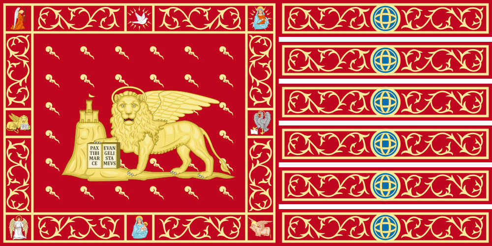
Venice at a glance
- Name
- Venice
- Country
- Italy
- Profile type
- City
- Landscape
- Lagoon on the northern Adriatic
- Region
- Veneto
- Historical quarters
- Six sestieri
- Large water axis
- Grand Canal
- Protective patron
- Evangelist Markus
- World Heritage Inspection
- 1987
- World Heritage Coverage
- City and lagoon together
- Historic seat of government
- Doge's Palace
The Flag of Venice
The flag shown bears the golden winged Mark's lion on a red background. Striking ornaments and the structured fly edge belong to the depicted Venetian appearance. The lion holds a book. For identification, wings, color and lion figure together are especially helpful; an ordinary unwinged lion would not be a complete description of this motif.
The lion is the Christian sign of the evangelist Markus, the patron saint of Venice. The city also tells the legend of an angel in lion form. This story is to be classified as a religious tradition. Historically, the republic linked the sign with its rule and used it widely; today's city flag, historical republic and regional flag are nevertheless distinguishable contexts.
Venice: Location and Territorial Role
Venice is located in the northeast of Italy in the Veneto region. The UNESCO World Heritage Site includes the historic city and its lagoon in common. The built-up island town is therefore only a part of the larger cultural landscape. Water surfaces, smaller settlements and the connections between them are as much a part of the understanding of this space as the famous squares and palaces.
The historic city is divided into six sestieri. Canals and small watercourses form their own network, while bridges connect the paths on foot. This structure is fundamentally different from a city with ordinary road blocks. Anyone looking at a map should therefore read both waterways and foot connections; they open up different movements through the same urban space.
Landscape, History and Culture
The Grand Canal is one of the most important water axes. Together with smaller canals, he divides the historical buildings. But the lagoon is not an immutable background: natural processes and human interventions have shaped it together. The relationship between islands, water levels and buildings explains why Venice can only be understood as a unity of settlement and ecosystem.
Venice developed into an important naval power in the Middle Ages. Churches, palaces and public buildings preserve the traces of far-reaching cultural and economic connections. The Mark's lion became a dominion sign beyond the city. The communal presentation of his history also shows that many lion images were changed, destroyed or later recreated and by no means all come from the same epoch.
Since 1987, Venice and its lagoon have been on the UNESCO World Heritage List. The preservation concerns not only facades, but also living functions, craftsmanship and the handling of water. UNESCO describes, among other things, the strong visitor pressure and extraordinary flooding as challenges. This makes it clear that World Heritage Protection also includes the continued existence of a living urban fabric.
St. Mark's Square and Doge's Palace
The area around San Marco brings together religious and political representation. St. Mark’s Cathedral and the Doge’s Palace are among the buildings that particularly clearly convey Venice’s former position. Its importance is also evident from the location of the water: squares, facades and moorings were parts of a city whose connections extended beyond the lagoon and far beyond.
Canal Grande and Sestieri
The large canal and the six historic quarters provide orientation without replacing the finer network of paths. Small bridges, alleys and squares create many local connections. Especially the comparison of water perspective and footpath shows that one and the same building in Venice can belong to several urban spaces at once.
Lagoon as a Cultural Landscape
UNESCO highlights the interplay between nature and human design. Island towns and water areas together form a historically grown space. A look beyond the main islands therefore helps to classify the famous architecture: it is the result of long-term adaptation to a special environment and remains dependent on its ecological and hydraulic conditions.
Explore this country and nearby profiles
 Italy
 Rome
 Florence
 Milan
 Lombardy
 Sicily
What did you discover?
Take this flag into the quiz
Sources and image credits
This English article draws on the institutional sources listed below. Figures and memberships retain their stated reference dates.
Source record: 2 November 2026. A translation does not change the reference date of a figure or membership list.
- live.comune.venezia.it/it/node/132935
- whc.unesco.org/en/list/394
- comune.venezia.it/it/node/7846
- veneziaunica.it/it/cosa-fare-a-venezia/il-territorio-di-venezia
- commons.wikimedia.org/wiki/File%3AFlag_of_Venice.svg