Rotterdam: City Flag, History and Identity
Rotterdam associates its name with a dam in the Rotte, but its current cityscape with the Nieuwe Maas and the access to the North Sea. The green-white-green flag is strikingly simple. Behind it stands a city history of hydraulic engineering, port expansion and profound reconstruction that stretches far beyond the historic city center.
Test your knowledge →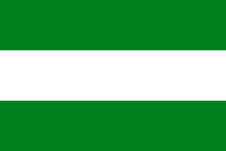
Rotterdam at a glance
- Name
- Rotterdam
- Country
- Netherlands
- Profile type
- City
- Name flow
- Rotten
- Downtown water area
- Nieuwe Maas
- Dam in the Rotte
- Around 1270
- City rights
- 1340
- Enlargement to the Maas
- From 1575
- Nieuwe Waterweg
- Construction 1866–1872
- Hydraulic engineering engineer
- Pieter Caland
- Incorporation of Delfshavens
- 1886
- Hoek van Hollands
- 1914
- Destruction of the city centre
- Air raid on 14 May 1940
The Flag of Rotterdam
The flag shown here consists of three equally high horizontal paths: green above, white in the middle and green below. Neither coat of arms nor writing nor stars are on the cloth. Therefore, the sequence and uniformity of the strips are decisive for the reliable recognition. The flag condenses the communal identity into two colors.
A figurative interpretation should claim no more than can be proven. From the green stripes alone there is no certain statement about meadows, hope or landscape. In the present city portrait, the visible pattern is therefore the focus. The richer history of Rotterdam is explained by the city and port sources, not by a fictitious color legend.
Rotterdam: Location and Territorial Role
Rotterdam is in the west of the Netherlands. The name goes back to the dam in the Rotte built around 1270. The later development was increasingly directed towards the Maas. The City Archives mentions 1340 as the year of the city rights award. Name creation, hydraulic engineering and legal urbanisation can thus be distinguished as different, interrelated processes.
The historical extension to the Meuse began in 1575. It shaped the so-called city triangle with several port basins and waterways. Today’s municipality also includes former independent places. Delfshaven joined in 1886, Hoek van Holland in 1914. The communal borders therefore tell a different story than the medieval settlement center on the Rotte.
Landscape, History and Culture
The situation in the river delta opened up trade opportunities, but also brought problems. In the 19th century, silting threatened the accessibility of the port. Engineer Pieter Caland developed a new connection through the dunes at Hoek van Holland. This hydraulic engineering project made the relationship between city, sea and hinterland a technical design task.
The Nieuwe Waterweg was built between 1866 and 1872. Its history shows that a large seaport is not created solely by a favorable natural location. Grooves, accesses and port areas must be continuously adapted. The current port area is therefore the result of many decisions that responded to changes in ship sizes, transport volumes and economic connections.
The air raid of 14 May 1940 destroyed large parts of the city centre. The subsequent reconstruction contributes significantly to the modern appearance of Rotterdam. This explains why the city does not everywhere correspond to the common image of a Dutch old town with a dense historical canal border. Different construction periods and expansion areas are particularly close together here.
Delfshaven
Delfshaven allows you to look at a different time shift. The formerly independent town became part of Rotterdam in 1886 and has its own local history. Such integrated areas are important for a city portrait: they show that municipal growth does not only occur through new developments, but also through the administrative consolidation of existing settlements.
Hoek van Holland
Hoek van Holland marks the reference to the North Sea. As a place belonging to Rotterdam since 1914, it is also in connection with the Nieuwe Waterweg. The name makes it clear that the port city must be thought out beyond the central shore scenery. The path to the sea is its own spatial part of its history and communal geography.
Stadsarchief Rotterdam
The Rotterdam City Archives not only preserves documents from the city administration, but also material from former municipalities and private institutions. His collections therefore open up the diversity of a grown port city. Maps, pictures and communal files complement each other: they show the change of waterways and city limits as well as the living environments behind the great historical dates.
Explore this country and nearby profiles
 Netherlands
 Amsterdam
 The Hague
What did you discover?
Take this flag into the quiz
Sources and image credits
This English article draws on the institutional sources listed below. Figures and memberships retain their stated reference dates.
Source record: 2 November 2026. A translation does not change the reference date of a figure or membership list.
- stadsarchief.rotterdam.nl/en/rotterdam-en
- portofrotterdam.com/en/experience-online/history-port
- rotterdamuas.com/study-information/why-study-in-holland/rotterdam/history-of-rotterdam/
- stadsarchief.rotterdam.nl/en/archives-and-collections
- commons.wikimedia.org/wiki/File%3AFlag_of_Rotterdam.svg