Barcelona: City Flag, History and Identity
Barcelona connects a Roman old town with the planned extended city of the industrial age. Between the Mediterranean coast and the rivers of Besòs and Llobregat, a port, commercial district and the famous houses of Catalan Modernisme were built. As the capital of Catalonia, Barcelona also has a political role that goes beyond the tasks of local administration.
Test your knowledge →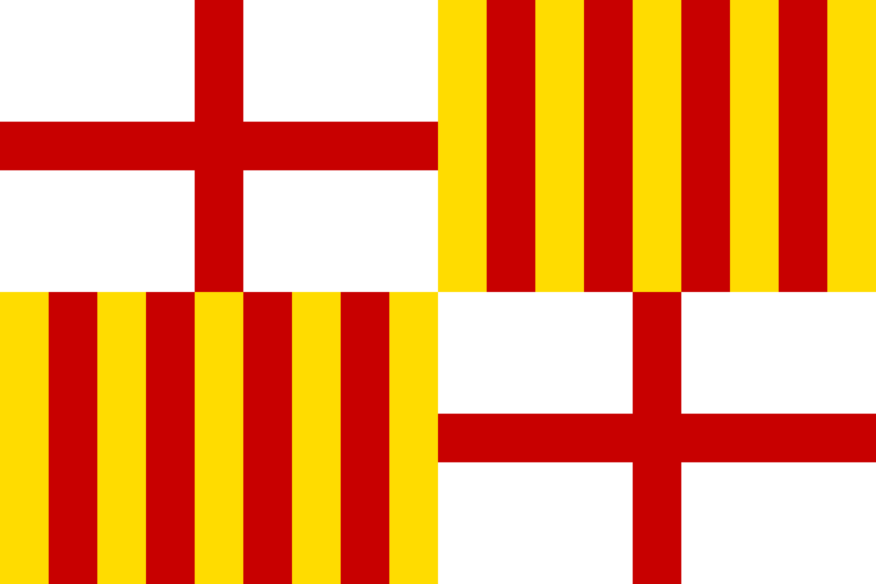
Barcelona at a glance
- Name
- Barcelona
- Country
- Spain
- Profile type
- City
- Coastal rivers
- Besòs and Llobregat
- Ancient name
- Barcino
- Ancient settlement mounds
- Mont Tàber
- Museum of Urban History
- MUHBA
- Planner of Eixample
- Ildefons Cerdà
- Grid feature
- House blocks with slanted corners
- Historical start of port construction
- 1477
- Former lighthouse
- Torre del Rellotge
The Flag of Barcelona
The city flag is divided into four fields. In two opposite quarters, a red George's Cross stands on white; the other two show red vertical beams on gold. This combination distinguishes the city flag from a simple Catalan stripe flag and remains well recognizable even in small display.
The cross fields and the red golden fields combine urban and Catalan heraldic traditions. In learning, therefore, the four-division helps more than the mere color combination. The flag shown here belongs to the city of Barcelona; it is neither the Spanish national flag nor a general flag of all places in Catalonia.
Barcelona: Location and Territorial Role
Barcelona is located on the northeastern Mediterranean coast of Spain. The historic city developed on the plain between the deltas of Besòs and Llobregat. Its position as the Catalan capital is particularly evident in Plaça Sant Jaume, where the old city centre and political institutions come together.
The city floor plan shows two very different orders. In the old town, some streets still follow the axes of the Roman colony of Barcino. In the Eixample, on the other hand, regularly created house blocks form a large grid. Sloped block corners open the crossings and make this part of Barcelona unmistakable from a bird’s eye view.
Landscape, History and Culture
The coastal location explains much of Barcelona's development, but today's port is not an unchanged natural basin. Port constructions, piers and built-up areas shaped the water edge for centuries. The hill Montjuïc and the coastal plain therefore offer different approaches to the city's history: one via landscape, the other via shipping and technical transformation.
The Roman colony originated in Augustean times on Mont Tàber. Under the present city, streets, houses and economically used spaces were preserved. The Stadtgegeschichtesmuseum MUHBA makes such findings accessible. Barcelona can thus be read both above ground as a densely inhabited city and below ground as an archaeological archive.
The Eixample is associated with the name of the engineer Ildefons Cerdà. His design provided for evenly distributed urban facilities and comparable neighbourhoods. Later, wealthy builders and architects of Modernisme shaped the facades. The ideal of planning and individual architecture are visibly next to each other here, instead of merging into a uniform historical style.
Roman Barcelona
In the court at Carrer Paradís stand preserved pillars of the Augustus Temple. Together with the excavations at Plaça del Rei, they illustrate the location of the ancient city centre. Particularly illuminating is the change between today's alleys and the underlying traces of Roman houses and streets.
Eixample and Modernisme
Cerdàs Raster forms the common stage for very different houses. Casa Batlló and La Pedrera are among the well-known examples of Modernisme. During a walk through the district, it is worthwhile to look at materials such as ceramics, stone and wrought iron as well as at the chamfered corners.
Port and Barceloneta
The first works for a protected artificial harbour began in 1477. They changed the coast in the area of the later Barceloneta. As a former lighthouse, the Torre del Rellotge is a reminder that today’s urban quarters and public spaces are located on a technically engineered water edge for a long time.
Explore this country and nearby profiles
 Spain
 Madrid
 Catalonia
 Andalusia
What did you discover?
Take this flag into the quiz
Sources and image credits
This English article draws on the institutional sources listed below. Figures and memberships retain their stated reference dates.
Source record: 2 November 2026. A translation does not change the reference date of a figure or membership list.
- meet.barcelona/en/visit-and-love-it/barcelona-history/roman-barcino
- fr.visitbarcelona.com/wv3/en/page/19/eixample.html
- portdebarcelona.cat/en/know-port/history
- commons.wikimedia.org/wiki/File%3AFlag_of_Barcelona.svg