Djibouti Flag, Capital and Country Facts
Djibouti is located on the Horn of Africa, where the Red Sea is connected to the Gulf of Aden via the strait Bab al-Mandab. The capital bears the same name as the state. Dry mountains, volcanic landscapes and the low-lying Assalsee stand alongside the supraregional importance of ports and traffic routes.
Test your knowledge →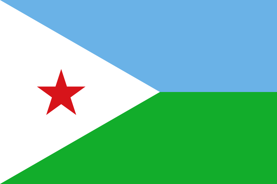
Djibouti at a glance
- Capital
- Djibouti
- Quiz continent
- Africa
- Languages in reference record
- French and Arabic (official languages); Somali and Afar are widely spoken
- Currency
- Djibouti franc (DJF)
- Population
- 1,184,076 (2025, World Bank)
- Area
- 23,200 km²
- Coastal setting
- Not landlocked
- ISO codes
- DJ / DJI
- Internet country suffix
- .dj
- Lowest point
- Assalsee, about −155 m
- Highest point
- Moussa Ali, 2.021 m
- Independence
- 27 June 1977
- Strait
- Bab al-Mandab
- Capital Bay
- Gulf of Tadjoura
- Important everyday languages
- Somali and Afar
Djibouti Flag: Design, Meaning and History
The flag has two equally high horizontal stripes: light blue at the top and light green at the bottom. A white triangle extends from the mast into the cloth; in it stands a red five-pointed star. Together, the triangle and star make the most distinct difference from a simple two-colored stripe flag.
The colors are associated with sea and sky, land and peace. In the traditional interpretation of the state, blue and green also stand for the Somali and Afar population. The red star refers to the struggle for independence and unity. The signs thus connect landscape references and the political emergence of the state.
Capital: Djibouti
Djibouti City is located on the Gulf of Tadjoura near the entrance to the Gulf of Aden. Its port connects maritime routes with inland Africa. Capital and country name are identical, but the urban coastal area differs significantly from the dry mountain and valley landscapes inland.
The position as a port city explains the close connection with neighboring Ethiopia, which does not have its own sea coast. Djibouti’s importance cannot therefore be derived from its surface alone. Transport links and the location on an international sea route give the capital a role that extends beyond the small state.
Practise this capital →Djibouti: Geography, History and Culture
The interior includes coastal plains, plateaus, mountains and deep sinks. Lake Assal is about 155 meters below sea level; Moussa Ali, on the other hand, reaches 2,021 meters. There is a considerable difference in elevation between the two values, although Djibouti is one of Africa's small countries in terms of area.
The climate is very dry and hot. Salt landscapes and geologically young forms differ significantly from the wetter highlands of other parts of East Africa. The UNESCO Countries Overview lists the Assalsee and other landscapes as proposals for World Heritage; a proposal is not yet included in the actual World Heritage List.
Somali and Afar are among the most important everyday languages. French and Arabic have official status and reflect other historical and supra-regional links. Independence from France was achieved on June 27, 1977. The location at the intersection of African and Arabic transport and cultural areas explains this multi-layered linguistic classification.
Sea of Assal below sea level
The lake forms one of the deepest land points in Africa. Its deep location and dry surroundings make it a vivid counterpart to the high mountains on the edge of the country; altitude and climate together determine the landscape here.
Gate between the seas
Bab al-Mandab connects the Red Sea with the Gulf of Aden. Djibouti is on the African side of this bottleneck. For card learning, the strait connects the state directly with the opposite Arabian Peninsula.
Port for inland port
The transport relationship with Ethiopia shows the mutual importance of coastal and landlocked states. A port can serve much larger spaces than its immediate hinterland; Djibouti therefore plays a special role in regional trade.
Explore neighbouring and related places
 Eritrea
 Ethiopia
 Somalia
What did you discover?
Sources and image credits
This English article draws on the institutional sources listed below. Figures and memberships retain their stated reference dates.
Source record: 2 November 2026. A translation does not change the reference date of a figure or membership list.
- github.com/factbook/factbook.json/blob/144d6977b2b01ac1cbd220de754c0a005616760b/africa/dj.json
- data.worldbank.org/indicator/SP.POP.TOTL
- whc.unesco.org/en/statesparties/dj/
- github.com/mledoze/countries