Rwanda Flag, Capital and Country Facts
Rwanda lies in the East African highlands without access to the sea. Densely populated hills, Lake Kiwuse and the volcanoes in the northwest determine the landscape. The flag combines blue, yellow and green with a sun. Kigali is the political center; the memory of the 1994 genocide is indispensable to today’s description of the country.
Test your knowledge →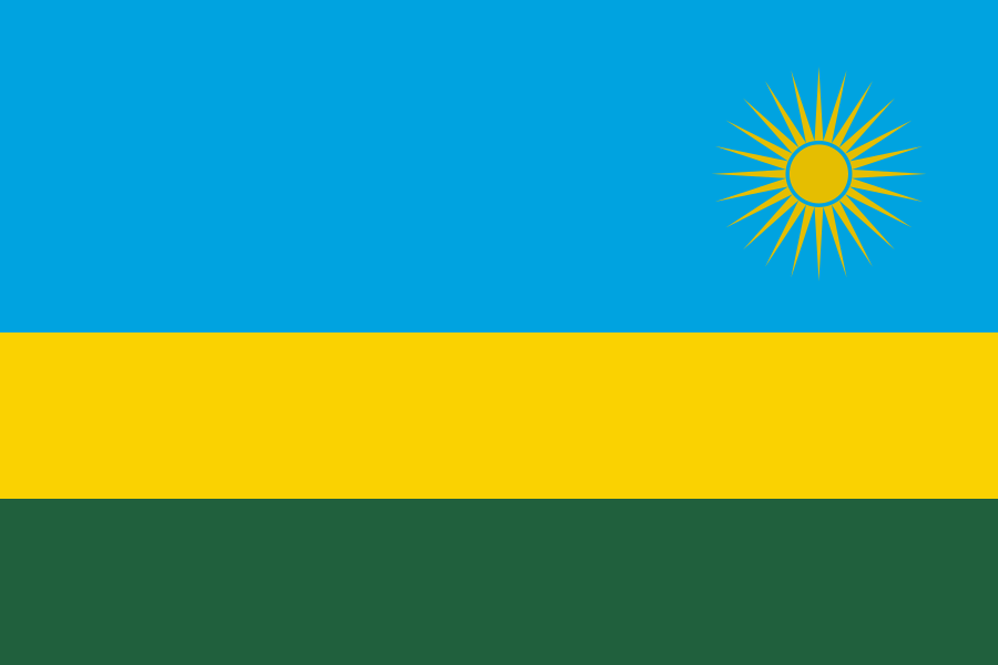
Rwanda at a glance
- Capital
- Kigali
- Quiz continent
- Africa
- Languages in reference record
- Kinyarwanda, English, French and Kiswahili
- Currency
- Rwanda franc (RWF)
- Population
- 14,569,341 (2025, World Bank)
- Area
- 26,338 km²
- Coastal setting
- Landlocked
- ISO codes
- RW / RWA
- Internet country suffix
- .rw
- Highest mountain
- Karisimbi, 4,519 m
- Greater Border Sea
- Kiwusee
- Independence
- 1 July 1962
- Today's flag
- Since 2001
- Mountain forest area
- Nyungwe
- Memorial in Kigali
- Gisozi’
Rwanda Flag: Design, Meaning and History
Three horizontal stripes form the flag. The blue upper stripe is twice as high as any of the lower yellow and green stripes. On the top right is a golden sun with 24 rays. The position of the sun and the broad blue area distinguish Rwanda from uniformly striped tricolors without additional signs.
Today's flag was adopted in 2001 and replaced the former red-yellow-green flag with a large R. Blue is associated with peace, yellow with economic development and green with hope; the sun stands for unity and knowledge. The change of symbol belongs to the state reorientation after 1994 and is not just a change of decorative colors.
Capital: Kigali
Kigali is located in the central part of the country on several hills and in its valleys. This location characterizes road guidance and cityscape. As the capital, the city concentrates administration, services and important transport links. However, the surrounding rural areas remain essential for the overall picture of a country whose limited area is intensively used.
Kigali is home to the Gisozi Memorial, part of the UNESCO World Heritage Site of Genocide Memorials. The reference makes it clear that the capital should not only be described as a modern urban development project. Places of remembrance serve to commemorate victims and provide historical mediation. They require a different access than ordinary tourist attractions.
Practise this capital →Rwanda: Geography, History and Culture
The west is characterized by the Kiwusee and higher mountain ranges. In the northwest are the Virunga volcanoes; the Karisimbi reaches 4,519 meters. To the east, the relief is lower overall. The high altitude influences the climate and explains why the temperatures do not have a typically hot tropical effect everywhere despite the proximity of the equator. Mountainous watersheds also connect Rwanda’s rivers with larger East and Central African catchments.
Kinyarwanda is the common language of a very large part of the population. English, French and Kiswahili are other official languages. The government portal explicitly confirms these four languages. Its different functions show links to regional trade, colonial history and international education. Official status does not mean that all people have equal command of every language.
In 1994, during the genocide, Tutsi in particular and opposition Hutu were murdered. This story must not be hidden or described as a timeless quality of a population. The factbook archive stand of 2025 cites agriculture and services as important economic sectors. Forest protection, land use and social development are closely related to the high population density.
Nyungwe
Nyungwe National Park became a UNESCO World Heritage Site in 2023. It protects an important mountain rainforest and complements the often better known volcanic landscapes.
Sites of remembrance
Nyamata, Murambi, Gisozi and Bisesero together form a World Heritage Entry. It preserves places of remembrance and mediation of genocide history.
Kiwusee
Rwanda shares Lake Kiwuse with the Democratic Republic of Congo. Natural areas and their protection and use issues thus extend beyond the state border.
Explore neighbouring and related places
 Burundi
 Democratic Republic of the Congo
 Tanzania
 Uganda
What did you discover?
Sources and image credits
This English article draws on the institutional sources listed below. Figures and memberships retain their stated reference dates.
Source record: 2 November 2026. A translation does not change the reference date of a figure or membership list.
- github.com/factbook/factbook.json/blob/144d6977b2b01ac1cbd220de754c0a005616760b/africa/rw.json
- data.worldbank.org/indicator/SP.POP.TOTL
- whc.unesco.org/en/statesparties/rw
- gov.rw/about
- github.com/mledoze/countries