Oman Flag, Capital and Country Facts
Oman is located in the southeast of the Arabian Peninsula and overlooks the Gulf of Oman and the Arabian Sea. Muscat is the capital on the northern coast. Mountains, deserts and the south around Salala, which is influenced by the summer monsoon, form strong contrasts; the Musandam peninsula lies as a separate part of the country on the Strait of Hormuz.
Test your knowledge →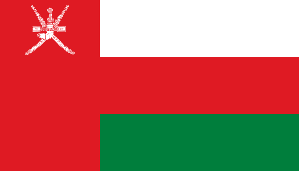
Oman at a glance
- Capital
- Muscat
- Quiz continent
- Asia
- Languages in reference record
- Arabic, including Baloch and other regional languages
- Currency
- Omani rial (OMR)
- Population
- 5,494,691 (2025, World Bank)
- Area
- 309,500 km²
- Coastal setting
- Not landlocked
- ISO codes
- OM / OMN
- Internet country suffix
- .om
- Highest mountain
- Jabal Shams, 3,004 m according to the archive
- Northern Mountains
- Hazard
- Southern Region
- Dhofar
- Separate part of the country
- Musandam
- Flag symbol
- Khanjar dagger
- Historical irrigation
- Aflaj systems
Oman Flag: Design, Meaning and History
The flag shows horizontal stripes in white, red and green. A red vertical beam connects them on the mast. At the top of this beam stands the white state sign: a curved dagger in its vagina over crossed swords. Red thus appears both as a transverse stripe and as a lateral field.
The dagger is called Khanjar and is one of the most striking Omani signs of state. White is associated with peace, green among other things with fertility and the Green Mountains; red has historical references to struggles against outside forces. The color alone is not enough for recognition: the Khanjar distinguishes Oman from similarly constructed Arab flags.
Capital: Muscat
Muscat lies between the sea and rocky heights. The common German form Muscat and the international spelling Muscat denote the same capital. The mountain location limited the historical harbour space and explains why sea and rocky relief are so directly part of the cityscape; it is not a city in the middle of an evenly flat sand desert.
The coastal location connects Muscat with Oman’s long maritime history. Exchange over the Indian Ocean supplemented the connections to the Arab inland. This maritime orientation is important for understanding the country: desert and caravan routes explain only part of the history, while ports and overseas relations form another central level.
Practise this capital →Oman: Geography, History and Culture
The Hadscharge mountain characterizes the north; the Jabal Shams reaches 3,004 meters according to the factbook archive. Inside are dry basins and desert spaces. Dhofar in the south, on the other hand, is seasonally influenced by monsoon. The change between dry north and summery wetter southern slopes makes Oman more climatically diverse than its location on the Arabian Peninsula initially suggests.
Musandam is separated from the main territory on the Strait of Hormuz. Between the two parts are the United Arab Emirates. The segregated part of the country illustrates Oman’s strategic sea location and is particularly important for map learning: a state border does not have to enclose a single contiguous piece of land, even if the country is not an island nation.
UNESCO runs, among others, the fortress Bahla, archaeological sites of Bat, the Aflaj irrigation systems and the land of incense. Water technology in particular shows the connection between the environment and settlement. Canals and communal water distribution enabled the use of dry spaces; incense in turn connects the southern landscape with historical trade networks.
Aflaj and water distribution
Traditional irrigation plants are both technical and social proofs. They lead water to settlements and cultivation areas and require rules for its use. Their UNESCO status is therefore not only explained by visible channels, but also by long-term organized use of the landscape.
Country of incense
The World Heritage site in Dhofar connects places of extraction and trade with incense. It shows the historical economic importance of a southern region, whose climate and landscape are clearly different from the dry picture of many other parts of the country.
Musandam at the bottleneck
The exclave is located on the Strait of Hormuz, an important access to the Persian Gulf. Its special location connects political border management with maritime geography; on a map it should therefore be sought together with the main territory.
Explore neighbouring and related places
 Saudi Arabia
 United Arab Emirates
 Yemen
What did you discover?
Sources and image credits
This English article draws on the institutional sources listed below. Figures and memberships retain their stated reference dates.
Source record: 2 November 2026. A translation does not change the reference date of a figure or membership list.
- github.com/factbook/factbook.json/blob/144d6977b2b01ac1cbd220de754c0a005616760b/middle-east/mu.json
- data.worldbank.org/indicator/SP.POP.TOTL
- whc.unesco.org/en/statesparties/om/
- github.com/mledoze/countries