United Arab Emirates Flag, Capital and Country Facts
The United Arab Emirates connects seven Emirates to one state on the Arabian Peninsula. Between sand deserts, oases, mountain valleys and international port cities are very different habitats. For the country quiz is especially important: The capital is called Abu Dhabi, while Dubai is a different emirate and a different city.
Test your knowledge →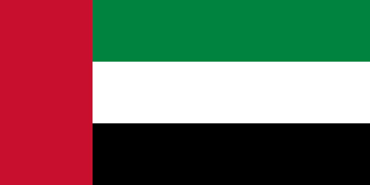
United Arab Emirates at a glance
- Capital
- Abu Dhabi
- Quiz continent
- Asia
- Languages in reference record
- Arabic; English and numerous immigration languages are also common
- Currency
- UAE Dirham (AED)
- Population
- 11,513,149 (2025, World Bank)
- Area
- 83,600 km²
- Coastal setting
- Not landlocked
- ISO codes
- AE / ARE
- Internet country suffix
- .ae, امارات.
- Establishment of the State
- 2 December 1971
- Accession of the Seventh Emirate
- Ras al-Khaimah, 1972
- Breakdown
- Seven Emirates
- Cultural site
- Oases and cultural sites of Al Ain
- National symbol
- Golden Falcon
- Eastern Mountains
- Hadschargebirge
United Arab Emirates Flag: Design, Meaning and History
Green, white and black lie on top of each other as three horizontal stripes of equal height. At the mast, it connects a vertical red field. It is precisely this combination of cross-strip and red sidebar that distinguishes the flag from other Arabian tricolors, which use similar colors but show different arrangements.
The four colors belong to the pan-Arabic color tradition. Red was already present in the flags of the individual Emirates before they joined together. The common flag can therefore be read as a visible sign of the Federation; individual popular color explanations should be distinguished from this proven historical connection.
Capital: Abu Dhabi
Abu Dhabi lies on the coast of the Persian Gulf and is also the name of the largest emirate in terms of area. The capital functions belong to the federal level, while the Emirates have their own rulers and administrative structures. Anyone who equates Abu Dhabi and Dubai thus confuses two members of the same federation.
Political geography also explains why large cities and vast desert spaces oppose each other within a country. Abu Dhabi and Dubai together occupy the vast majority of the state area. Sharjah, Ajman, Umm al-Qaiwain, Ras al-Khaimah and Fujairah complete the seven emirates and expand the picture beyond the two most famous names.
Practise this capital →United Arab Emirates: Geography, History and Culture
A shallow coastal zone merges inland into dune landscapes. In the east, the rocky foothills of the Hadscharge Mountains are added; there, relief and local temperatures differ significantly from the coastal plain. The Emirates have access to both the Persian Gulf and, at Fujairah, the Gulf of Oman.
The oases of Al Ain show that the history of this region does not begin with oil and high-rise buildings. The UNESCO ensemble includes oases, tombs and settlement remains. Irrigation techniques, including the Falaj system, made permanent settlement possible in a dry environment, combining agriculture with millennia-old landscape design.
Six Emirates founded the federation on December 2, 1971; Ras al-Khaimah joined in 1972. Petroleum and natural gas shaped economic change, alongside trade, transport and financial services. Arabic is an official language, but the strong international labour migration explains the multitude of other languages in everyday life.
Al Ain as an oasis landscape
UNESCO pays tribute to the interplay between oases, archaeological sites and desert landscapes. Water management and settlement history are directly related: without planned watering, the historical gardens and their permanent use would be hard to understand.
Two sea access points
Fujairah is located on the Gulf of Oman, while large parts of the rest of the coast belong to the Persian Gulf. This location connects the country with different shipping areas and makes the Musandam peninsula important for its geographical arrangement.
Seven Parts of a Federation
An emirate is a political sub-area, not a mere town designation. The difference explains why names like Abu Dhabi and Dubai can be on maps for both cities and larger territories.
Explore neighbouring and related places
 Oman
 Saudi Arabia
What did you discover?
Sources and image credits
This English article draws on the institutional sources listed below. Figures and memberships retain their stated reference dates.
Source record: 2 November 2026. A translation does not change the reference date of a figure or membership list.
- github.com/factbook/factbook.json/blob/144d6977b2b01ac1cbd220de754c0a005616760b/middle-east/ae.json
- data.worldbank.org/indicator/SP.POP.TOTL
- whc.unesco.org/en/list/1343/
- github.com/mledoze/countries