North Korea Flag, Capital and Country Facts
North Korea occupies the northern part of the Korean Peninsula. The country lies between China, Russia and South Korea and has coasts on two seas. Mountains dominate large parts of the inland; Pyongyang lies in the western river area. Historical sites of Koguryŏ and Kaesŏng provide a glimpse into the history before today’s division.
Test your knowledge →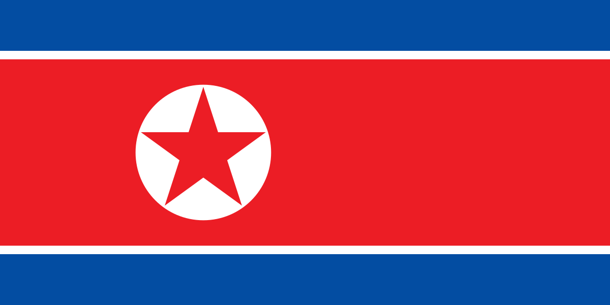
North Korea at a glance
- Capital
- Pyongyang
- Quiz continent
- Asia
- Languages in reference record
- Korean
- Currency
- North Korean won (KPW)
- Population
- 26,571,036 (2025, World Bank)
- Area
- 120,538 km²
- Coastal setting
- Not landlocked
- ISO codes
- KP / PRK
- Internet country suffix
- .kp
- Highest mountain
- Paektusan, 2,744 m according to the archive
- Capital river
- Taedong
- Northern Border River
- Yalu/Amnok
- Further border flow
- Tubes
- Historical centre
- Kaesong
- Armistice in the Korean War
- 1953
North Korea Flag: Design, Meaning and History
A wide red middle strip lies between narrower blue outer stripes and is bounded by white lines. On the left in the red field is a white disc with a red five-pointed star. The laterally offset disc is more important for recognition than the general combination of red, white and blue.
The star belongs to the socialist state sign world. The official interpretation combines red with revolutionary traditions, blue with sovereignty and peace, and white with purity and dignity. These attributions describe the political symbolism of the flag and should remain recognizable as such, instead of being considered neutral statements about the population.
Capital: Pyongyang
Pyongyang is located on the Taedong River in the west of the country. The name is associated with flat land. The location on a plain distinguishes the capital area from the extended mountain ranges in the north and east. Pyongyang is the capital of North Korea; Seoul is the capital of neighboring South Korea.
The current political role must be separated from the much older history of the region. Nearby are burial grounds of the historic Koguryŏ empire, which belong to the UNESCO World Heritage. A modern state border and a historical cultural area have different dimensions; older empires can therefore not easily be equated with the present state.
Practise this capital →North Korea: Geography, History and Culture
North Korea’s terrain is largely mountainous, with narrower plains especially in the west. The Paektusan on the border with China reaches 2,744 meters according to the Factbook archive. Rivers such as Yalu and Amnok and Tumen form sections of the northern border. Relief and border waters help to understand the shape of the country on the map.
The Korean Peninsula was divided in the 20th century. The Korean War ended in 1953 with a ceasefire, not a peace treaty. The demilitarized zone separates North and South Korea. This historical context explains today’s political geography without the need for changing government figures or current developments that are difficult to verify.
Korean is spoken on both sides of the peninsula, with differences in vocabulary and language usage. Kaesŏng in the south of North Korea was an important center of the Koryŏ dynasty. Its UNESCO ensemble of historical monuments and sites complements the Koguryŏ tombs and commemorates different eras of common Korean history.
Koguryŏ Tombs
UNESCO protects a complex of historical tombs, some of which have significant murals. They open up religious ideas and living worlds of an older epoch and stand for a historical context that lies well before the founding of North Korea.
Kaesŏng and Koryŏ
Kaesŏng preserves monuments of an earlier Korean dynasty. The place is therefore important for the understanding of historical statehood and complements Pyongyang as today's capital; historical significance and current administrative function should be distinguished in learning.
Border mountain in the north
The Paektusan is on the border with China. Its altitude and location make it an important landmark for the mountainous north. On the Chinese side, other forms of names are common, which denote the same cross-border mountain range.
Explore neighbouring and related places
 China
 South Korea
 Russia
What did you discover?
Sources and image credits
This English article draws on the institutional sources listed below. Figures and memberships retain their stated reference dates.
Source record: 2 November 2026. A translation does not change the reference date of a figure or membership list.
- github.com/factbook/factbook.json/blob/144d6977b2b01ac1cbd220de754c0a005616760b/east-n-southeast-asia/kn.json
- data.worldbank.org/indicator/SP.POP.TOTL
- whc.unesco.org/en/statesparties/kp/
- github.com/mledoze/countries