Brunei Flag, Capital and Country Facts
Brunei is located on the north coast of Borneo and consists of two separate parts of the country. The Sultanate combines wet tropical forests with an economy strongly influenced by oil and natural gas. Its capital, Bandar Seri Begawan, lies in the greater western part; Temburong forms the eastern part of the country separated by Malaysian territory.
Test your knowledge →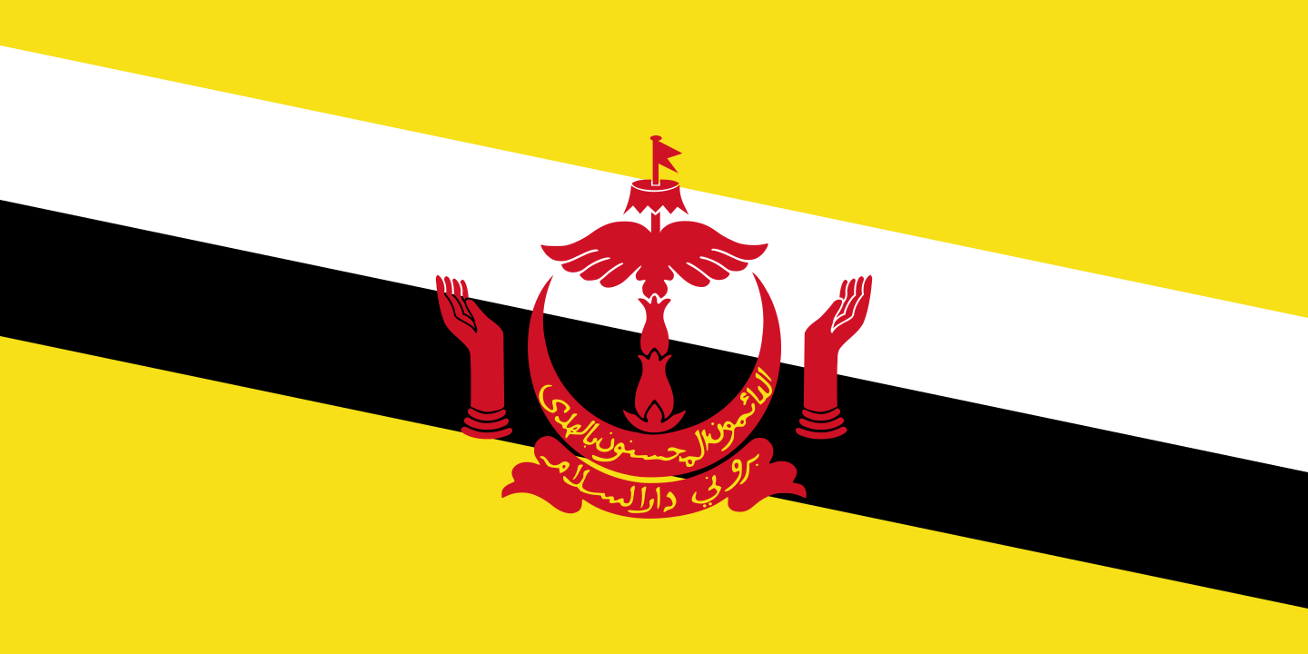
Brunei at a glance
- Capital
- Bandar Seri Begawan
- Quiz continent
- Asia
- Languages in reference record
- Malay (official language); also including English and Chinese languages
- Currency
- Brunei dollar (BND)
- Population
- 466,330 (2025, World Bank)
- Area
- 5,765 km²
- Coastal setting
- Not landlocked
- ISO codes
- BN / BRN
- Internet country suffix
- .bn
- Highest point
- Bukit Pagon, 1,850 m
- Districts
- Four
- Independence
- 1 January 1984
- National holiday
- 23 February
- Eastern part
- Temburong
- Water village
- Kampong Ayer
Brunei Flag: Design, Meaning and History
On a yellow background, two oblique bands run from top left to bottom right: top white, under black. In the middle is the red coat of arms. The yellow surface remains visible on both sides; just the combination of oblique stripes and applied coat of arms makes this flag very recognizable.
Yellow refers to the Sultanate, white and black to high traditional officials. The coat of arms contains, among other things, an umbrella, wings, hands and a crescent moon. Arabic inscriptions connect the state sign with Islam. The individual elements belong to a monarchical and religious sign language and are not a mere representation of the landscape.
Capital: Bandar Seri Begawan
Bandar Seri Begawan is the political center of Brunei and is located on the Brunei River. The cityscape includes Kampong Ayer, the well-known water village. The capital thus shows a special connection between river space and settlement: Living on the water is a historical part of the city here and not a tourist backdrop.
The city received its current name in 1970. He refers to the former Sultan Omar Ali Saifuddien III and his title after the abdication. Bandar means city or port. The long name should therefore be understood as a historically compound name, instead of confusing it with the country name Brunei.
Practise this capital →Brunei: Geography, History and Culture
Brunei borders the South China Sea and is surrounded by the Malaysian state of Sarawak. The western part is predominantly hilly, while the east has stronger mountain relief. Bukit Pagon reaches 1,850 meters. Coastal wetlands and further inland rainforests complement these topographical differences.
Temburong is spatially separated from the main area. There lies the Ulu Temburong National Park, whose forest landscape forms an important counterpole to the more populated coastal areas. The year-round warm and humid climate favors tropical vegetation; precipitation is part of the basic pattern and not just a brief European idea of summer rain.
The four districts are called Brunei-Muara, Tutong, Belait and Temburong. The economic geography distinguishes the capital region from the Seria and Kuala Belait regions, which are closely linked to oil and natural gas. Malay is an official language; in addition, English and various Chinese languages are used. Full independence from Britain took place on 1 January 1984.
Kampong Ayer
The water village belongs to the capital and makes its river location immediately visible. Its pile buildings and waterways are a reminder that urban traffic and settlement history in Brunei have long been closely linked to water.
Divided Territory
Between the western main part and Temburong lies Sarawak. Brunei is therefore a vivid example of a state whose coherent parts of the country are not immediately adjacent to each other on a political map.
A coastal state in Borneo
Borneo is larger than Brunei and is also shared by Malaysia and Indonesia. Brunei therefore does not include the whole island nor its entire north; this distinction helps to distinguish between state, island and neighbouring region.
Explore neighbouring and related places
 Malaysia
What did you discover?
Sources and image credits
This English article draws on the institutional sources listed below. Figures and memberships retain their stated reference dates.
Source record: 2 November 2026. A translation does not change the reference date of a figure or membership list.
- github.com/factbook/factbook.json/blob/144d6977b2b01ac1cbd220de754c0a005616760b/east-n-southeast-asia/bx.json
- data.worldbank.org/indicator/SP.POP.TOTL
- un.int/brunei/brunei/country-facts
- github.com/mledoze/countries