Nicaragua Flag, Capital and Country Facts
Nicaragua is located between Honduras and Costa Rica and has coasts on the Pacific and Caribbean. Great lakes and volcanoes characterize the West in particular, while the Caribbean side has other landscape and language areas. Managua is the capital; León and Granada are important historical cities whose names often appear alongside it without having the same current political function.
Test your knowledge →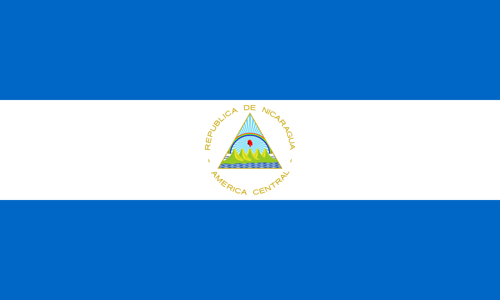
Nicaragua at a glance
- Capital
- Managua
- Quiz continent
- North America
- Languages in reference record
- Spanish; on the Caribbean coast also including Miskito, Creole English and other regional languages
- Currency
- Nicaraguan Córdoba (NIO)
- Population
- 7,007,502 (2025, World Bank)
- Area
- 130,373 km²
- Coastal setting
- Not landlocked
- ISO codes
- NI / NIC
- Internet country suffix
- .ni
- Highest mountain
- Mogotón, 2,085 m
- Capital Lake
- Lake Managua / Xolotlán
- Great Southern Sea
- Lake Nicaragua / Cocibolca
- Volcanic Islands
- Ometepe
- Outflow of Lake Nicaragua
- River San Juan
- National holiday
- 15 September
Nicaragua Flag: Design, Meaning and History
Three equally high horizontal stripes are blue, white and blue. In the middle of the white stripe stands the state coat of arms with a triangle and circulating writing. Among other things, volcanoes and a rainbow appear in it. The small coat of arms details help to delineate other Central American flags with the same stripe sequence.
The blue-white-blue design builds on the former Central American Federation. Blue is associated with the Pacific and Caribbean, white with the land in between. The five volcanoes in the coat of arms are reminiscent of the Central American tradition and cannot be read as a true-to-scale map of all volcanoes in Nicaragua.
Capital: Managua
Managua is located on the south bank of the lake of the same name, which is also called Xolotlán. The capital belongs to the western settlement area. It is not to be equated with the more southerly lake of Nicaragua: two large lakes shape the map, and the name of the capital refers to the more northerly of both.
The choice of Managua as capital in the 19th century was between the rival historical centers of León and Granada. Serious earthquakes later shaped the urban development. The history of the capital thus combines political location decisions with natural hazards; a purely historical idea of the old town fits less well than in some older neighbouring cities, whose building substance experienced other developments.
Practise this capital →Nicaragua: Geography, History and Culture
A volcanic zone runs along the Pacific part of the country. There are also the large lakes and important cities. Mountains rise inland; the Mogotón on the border with Honduras reaches 2,085 meters. The Caribbean lowlands, on the other hand, form a different natural area with extensive wet landscapes and long river courses.
Lake Nicaragua, also Cocibolca, is one of the most striking inland waters in Central America. The island of Ometepe is characterized by two volcanoes and illustrates the close connection between water and volcanism. The San Juan River drains the lake towards the Caribbean, although large parts of the western settlement area are close to the Pacific Ocean.
UNESCO lists the ruins of León Viejo and the Cathedral of León as World Heritage sites. Both are located in the same wider region, but show different aspects of the city’s history. On the Caribbean coast, there are linguistic and cultural traditions that complement the predominantly Spanish-speaking image of the West; parts of the country should therefore not be described as culturally uniform.
Keeping two lakes apart
Lake Managua and Lake Nicaragua are both located in the western part of the country. The capital is located on Lake Managua, while Ometepe belongs to Lake Nicaragua. This simple assignment prevents frequent confusion and creates a clear basic framework for the card.
León Viejo
The UNESCO ruins document an early colonial urban complex. They can be distinguished from today's León and its cathedral. Two World Heritage sites with a similar name denote different places and historical phases of development, not a mere duplication of the same attraction.
Ometepe in the lake
The island is characterized by two volcanic bodies. Its location within a large freshwater lake makes it a particularly vivid example of Nicaragua’s connection of inland waters and volcanic landscape; both belong to the same geological and spatial context.
Explore neighbouring and related places
 Costa Rica
 Honduras
What did you discover?
Sources and image credits
This English article draws on the institutional sources listed below. Figures and memberships retain their stated reference dates.
Source record: 2 November 2026. A translation does not change the reference date of a figure or membership list.
- github.com/factbook/factbook.json/blob/144d6977b2b01ac1cbd220de754c0a005616760b/central-america-n-caribbean/nu.json
- data.worldbank.org/indicator/SP.POP.TOTL
- whc.unesco.org/en/statesparties/ni/
- github.com/mledoze/countries