Guyana Flag, Capital and Country Facts
Guyana is located on the Atlantic coast of South America and connects a narrow populated coastal zone with an extensive forested hinterland. English as an official language distinguishes it from many neighboring states. The capital, Georgetown, is located on the Demerara. Those who confuse Guyana with French Guiana overlook an independent state with British colonial history and close ties to the Caribbean.
Test your knowledge →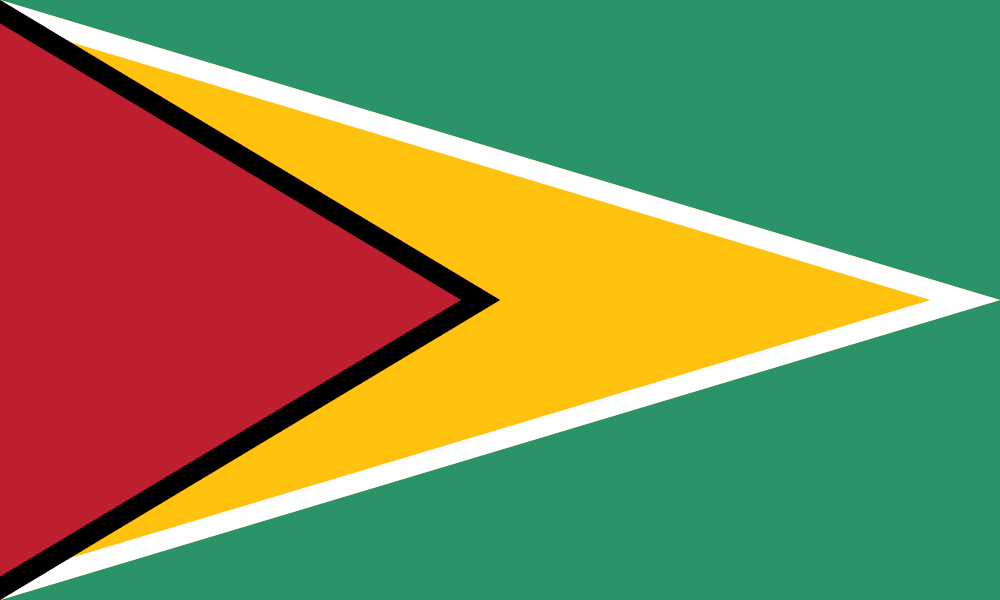
Guyana at a glance
- Capital
- Georgetown
- Quiz continent
- South America
- Languages in reference record
- English; Guyanese Creole and indigenous languages
- Currency
- Guiana dollar (GYD)
- Population
- 835,986 (2025, World Bank)
- Area
- 214,969 km²
- Coastal setting
- Not landlocked
- ISO codes
- GY / GUY
- Internet country suffix
- .gy
- Independence
- 26 May 1966
- Republic since
- 23 February 1970
- Capital river
- Demera
- River near Kaieteur
- Potaros
- Flag byname
- Golden arrowhead
- Waterfall height
- Kaieteur: about 226 m free drop height
Guyana Flag: Design, Meaning and History
The flag shows a long yellow arrowhead on a green background, extending from the left edge to the right. A narrow white line separates yellow from green. On the left is a shorter red triangle with a black border. The two triangles act as arrow shapes inserted into each other and are the most important distinguishing feature.
The motif is known as the “Golden Arrowhead”. Green is associated with forests, gold with mineral resources and white with the waters. In the traditional interpretation, red stands for operational readiness, black for endurance. The flag, which has been used since independence in 1966, differs from Timor-Leste’s similar triangular composition due to the additional white and black border.
Capital: Georgetown
Georgetown is located at the mouth of the Demerara River into the Atlantic Ocean. The capital is a port, administrative headquarters and a center of the narrow coastal zone where a large part of the population lives. Its location explains the importance of drainage and coastal protection in a very shallow landscape directly on the sea.
The city has traces of Dutch and British colonial history. Its current name is reminiscent of the British King George III. Water trenches, coastal installations and wooden historical buildings are part of the special urban design. Georgetown thus stands for a different landscape than the table mountains and waterfalls with which the interior is often depicted.
Practise this capital →Guyana: Geography, History and Culture
The coastal plain passes south into forest areas, highlands and savannahs. The landscape of the Guayana Shield extends across several state borders. In the border area, the Roraima rises as a striking table mountain. There are significant differences in accessibility, settlement and natural habitats between shallow coastal areas and remote highland areas.
The country’s population and culture have been shaped by indigenous communities, African enslavement, Indian contract work and further migration. English is an official language, while Creole and indigenous languages form their own everyday and cultural contexts. Geographical affiliation with South America and close social ties with the Caribbean region complement each other, rather than excluding each other.
The Kaieteur waterfall is located on the Potaro in the wooded interior. The state tourism organization calls a free drop height of 741 feet, about 226 meters. Especially the contrast to Georgetown is instructive: The capital is located on a wide river mouth in the lowlands, while Kaieteur makes an abrupt jump of the highlands visible. Mining and forest protection also touch these different landscapes.
Kaieteur at the Potaro
The famous waterfall is located in a national park inland. Its large free fall stage is surrounded by rainforest and differs from urban coastal landscapes.
Caribbean compounds
Guyana is located on the South American mainland. Language and colonial history at the same time connect it closely with many English-speaking Caribbean states.
Coastal position as a task
The low level at Georgetown requires protection and drainage. The proximity to the sea is therefore both a transport link and a technical challenge.
Explore neighbouring and related places
 Brazil
 Suriname
 Venezuela
What did you discover?
Sources and image credits
This English article draws on the institutional sources listed below. Figures and memberships retain their stated reference dates.
Source record: 2 November 2026. A translation does not change the reference date of a figure or membership list.
- github.com/factbook/factbook.json/blob/144d6977b2b01ac1cbd220de754c0a005616760b/south-america/gy.json
- data.worldbank.org/indicator/SP.POP.TOTL
- guyanatourism.com/kaieteur-falls/
- github.com/mledoze/countries