Suriname Flag, Capital and Country Facts
Suriname is located on the north coast of South America between Guyana, Brazil and French Guiana. A large part of the interior is covered by tropical forest, while most people live in the coastal area. The flag shows a yellow star on a wide red center stripe. Dutch distinguishes the country linguistically from most South American neighbors.
Test your knowledge →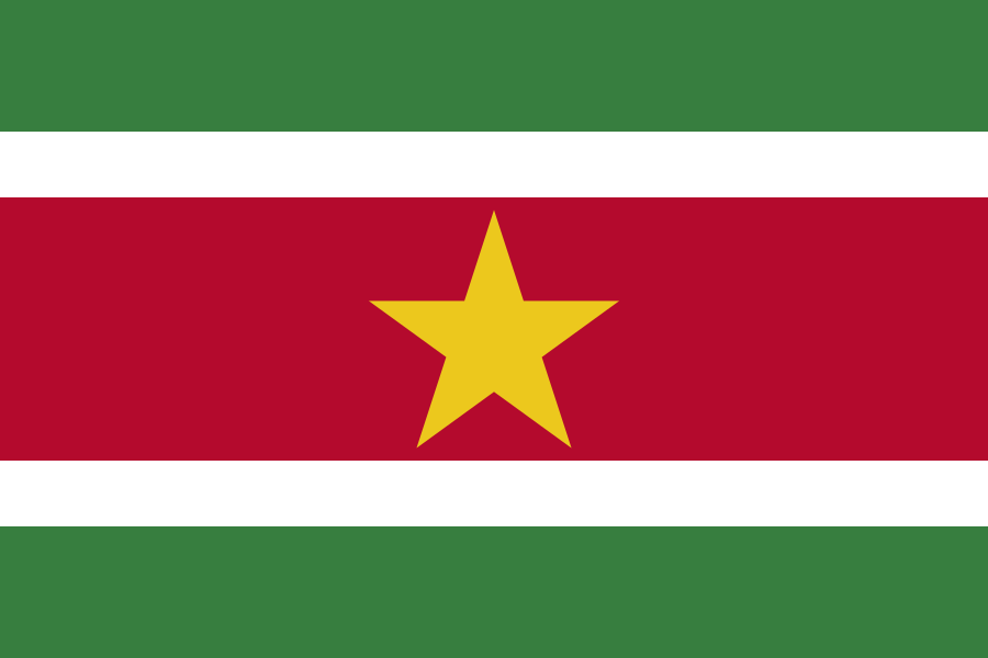
Suriname at a glance
- Capital
- Paramaribo
- Quiz continent
- South America
- Languages in reference record
- Dutch; also including Sranantongo, Sarnami, Javanese and indigenous languages
- Currency
- Surinam dollar (SRD)
- Population
- 639,850 (2025, World Bank)
- Area
- 163,820 km²
- Coastal setting
- Not landlocked
- ISO codes
- SR / SUR
- Internet country suffix
- .sr
- Highest mountain
- Juliana Top, about 1,230 m
- The River of the Capital
- Suriname
- Independence
- 25 November 1975
- Sea coastline
- Atlantic Ocean
- Natural World Heritage
- Central Surinam Nature Reserve
- Historical site
- Jodensavanne
Suriname Flag: Design, Meaning and History
Five horizontal stripes form the flag: green, white, red, white and green. The red and green areas are of different widths; the red middle strip is the widest. In its center stands a yellow five-pointed star. The two white stripes are narrow and separate red from green. This graduated width is part of the motif.
The star is understood as a sign of the unity of different population groups. The factbook archive of 2025 combines green with hope and fertility, white with peace and justice, and red with progress and love. The symbolism is aimed at cohesion. It should not lead to the assumption that Suriname has only one language or a single cultural origin.
Capital: Paramaribo
Paramaribo is located on the Suriname River near the Atlantic coast. The capital belongs to the more populated northern area and is the political and economic center of the state. The river connects the city with the sea and the hinterland. The eponymous designation of land and river is therefore a helpful geographical context.
The historic center of Paramaribos became a UNESCO World Heritage site in 2002. Its building history is closely linked to the Dutch colonial period and at the same time shows adaptations to the tropical environment. The cityscape can therefore not be meaningfully described as a mere copy of European architecture. Materials, climate and the work of different population groups were part of its creation.
Practise this capital →Suriname: Geography, History and Culture
The coastal plain differs significantly from the forested southern interior with rivers, rapids and higher relief. The distribution of settlements and traffic routes is correspondingly uneven. Moreover, a high proportion of forest does not mean that the landscape is without human history: Indigenous communities and Maroon communities have their own connections to the inland areas and their river systems.
Dutch is the official language; Sranantongo serves many people as a connecting everyday language. Sarnami, Javanese, indigenous and Maroon languages represent further historical contexts. Colonial slavery and later contract labor brought people into the country under very different conditions. This story explains linguistic diversity better than the blanket assignment of Suriname to just one cultural space.
The Central Suriname Nature Reserve is a UNESCO natural heritage site. The archaeological site Jodensavanne with the Cassipora Creek cemetery has complemented the cultural heritage since 2023. Together with Paramaribo, a complex picture emerges: tropical forest ecosystems, a colonial city and a historical Jewish settlement. The three entries represent different aspects of the same country.
Dutch in South America
Suriname has an official Dutch language history. However, its societal multilingualism extends significantly beyond this.
Forest as a Natural Heritage Site
The Central Suriname Nature Reserve was registered in 2000. It represents a different part of the country than the densely populated coastal zone.
Jodensavanne
The Cassipora Creek Cemetery has been a World Heritage Site since 2023. They complement the urban and natural heritage with a special historical perspective.
Explore neighbouring and related places
 Brazil
 Guyana
What did you discover?
Sources and image credits
This English article draws on the institutional sources listed below. Figures and memberships retain their stated reference dates.
Source record: 2 November 2026. A translation does not change the reference date of a figure or membership list.
- github.com/factbook/factbook.json/blob/144d6977b2b01ac1cbd220de754c0a005616760b/south-america/ns.json
- data.worldbank.org/indicator/SP.POP.TOTL
- whc.unesco.org/en/statesparties/sr
- github.com/mledoze/countries