São Paulo: City Flag, History and Identity
São Paulo is a Brazilian metropolis whose historical core was built on the Planalto de Piratininga. The city and state of the same name are different areas and carry different flags. The history of the Commune ranges from an early Jesuit foundation to trade and immigration to cultural institutions and large public parks such as Ibirapuera.
Test your knowledge →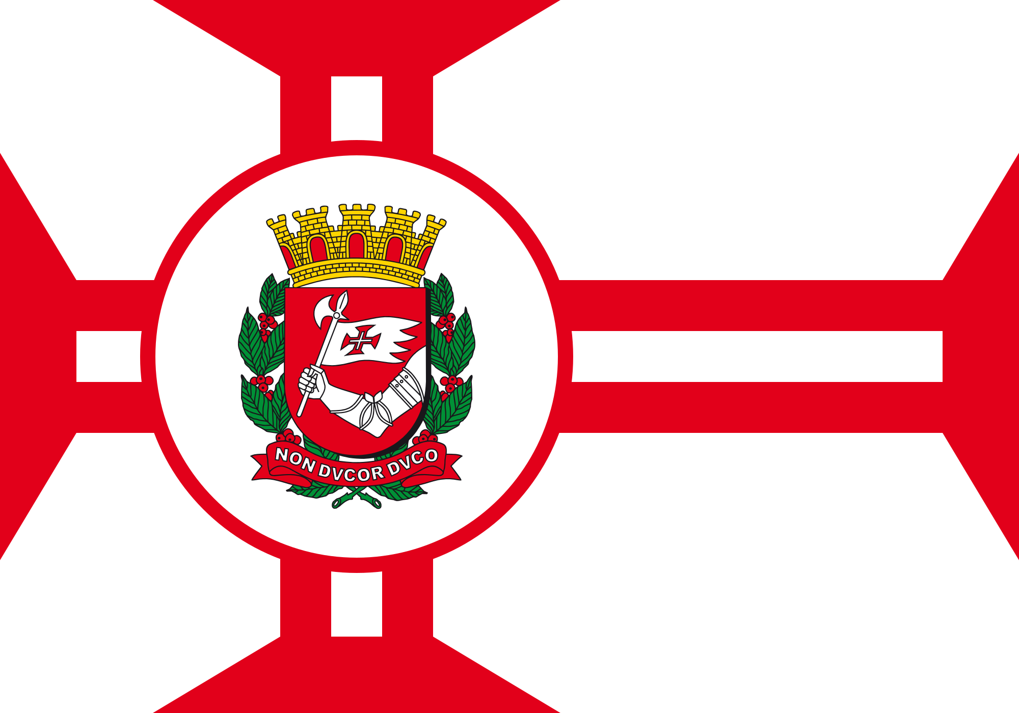
São Paulo at a glance
- Name
- São Paulo
- Country
- Brazil
- Profile type
- City
- Country of origin
- Planalto de Piratininga
- Historical town centre
- Triângulo Histórico
- Churches of the Historic Triangle
- São Bento, São Francisco and Carmo
- Selection of the city coat of arms
- 1917
- Coat of arms designers
- Guilherme de Almeida and José Wasth Rodrigues
- Ibirapuera opens
- 21 August 1954
- Reason for the opening of the parking facility
- Four hundredth anniversary of the city
- Architect in the parking planning team
- Oscar Niemeyer
The Flag of São Paulo
The white city flag carries a wide red cross. In its center is the city coat of arms in a round frame. White background, straight cross and central coat of arms form the decisive combination. It differs significantly from the black-and-white striped flag of the state of São Paulo with its red upper corner.
The communal memorial institution connects the cross with the foundation by Jesuits. The coat of arms emerged from a competition and was selected in 1917; its designers were Guilherme de Almeida and José Wasth Rodrigues. Later laws explained the symbols again. The age of the coat of arms may therefore not be readily treated as the date of acceptance of the entire flag.
São Paulo: Location and Territorial Role
The municipality of São Paulo is located in the state of the same name in the southeast of Brazil. Its historical starting point is on the highlands of Piratininga. This page is about the city flag and urban space. Statements about the entire regional region or the even larger metropolitan region are thus not automatically statements about the municipal area.
The historic center has long been described by the triangle of churches of São Bento, São Francisco and Carmo. From this comparatively small center, the city expanded into further quarters. Today’s picture of business streets, major traffic axes and widely spaced cultural locations is the result of several phases of urban expansion.
Landscape, History and Culture
The highland location distinguishes São Paulo from Brazilian cities, whose historical center is located directly on the shore of the sea. For orientation, the contrast between the old center and later expansion spaces is helpful here. The Ibirapuera Park offers an open space within this large urban landscape, where green spaces, paths and cultural buildings come together.
The communal guide describes the change of the center, especially in the nineteenth and early twentieth centuries. New infrastructure, trade and financial services supported expansion. With the republic, the architecture also changed. Theatres, cinemas and libraries complemented the economic functions and made the centre an important cultural reference point.
Immigration characterized São Paulo especially in the nineteenth and early twentieth centuries. The coffee trade created wealth, which also flowed into urban infrastructure and modernization. Immigrants brought knowledge and cultural traditions with them. This combination of migration, industrialization and art explains the diversity of the metropolis better than the idea of a city with only one unified history of origin.
Historical Triangle
São Bento, São Francisco and Carmo mark the traditional frame of reference of the early center. The name Triângulo Histórico is explained by this arrangement of churches. It helps to compare the former spatial boundary of the city with the later extensions and to classify historical paths within today's big city.
Ibirapuera
The park was opened on 21 August 1954 during the celebrations of São Paulo’s four hundredth anniversary. The planning team included Oscar Niemeyer and other architects as well as landscape architect Augusto Teixeira Mendes. The complex therefore combines city anniversaries, modern architecture and designed nature in a coherent public space.
Cultural space in the park
According to the urban description, Ibirapuera is at the same time a green area, a leisure place and a cultural space. This multiple function makes the park a counterpart to the bustling historical center. Instead of separating nature and city, the complex brings both together: recreation takes place here in direct relation to consciously designed architecture and cultural facilities.
Explore this country and nearby profiles
 Brazil
 Rio de Janeiro
What did you discover?
Take this flag into the quiz
Sources and image credits
This English article draws on the institutional sources listed below. Figures and memberships retain their stated reference dates.
Source record: 2 November 2026. A translation does not change the reference date of a figure or membership list.
- saopaulo.sp.leg.br/memoria/timeline/1917-o-brasao-e-a-bandeira-do-municipio/
- prefeitura.sp.gov.br/web/turismo/w/publicacoes/369067
- www2.prefeitura.sp.gov.br/web/meio_ambiente/w/parques/regiao_sul/14062
- prefeitura.sp.gov.br/web/governo/w/institucional/348594
- commons.wikimedia.org/wiki/File%3ABandeira_da_cidade_de_S%C3%A3o_Paulo.svg