Rio de Janeiro: City Flag, History and Identity
Rio de Janeiro is a coastal city whose landmarks consist not only of individual buildings. Mountains, forest, beaches and the Guanabara Bay together shape their image. The white city flag with blue St. Andrew’s Cross and a coat of arms in the middle belongs to the city; it can be distinguished from the flag of the Brazilian state of the same name.
Test your knowledge →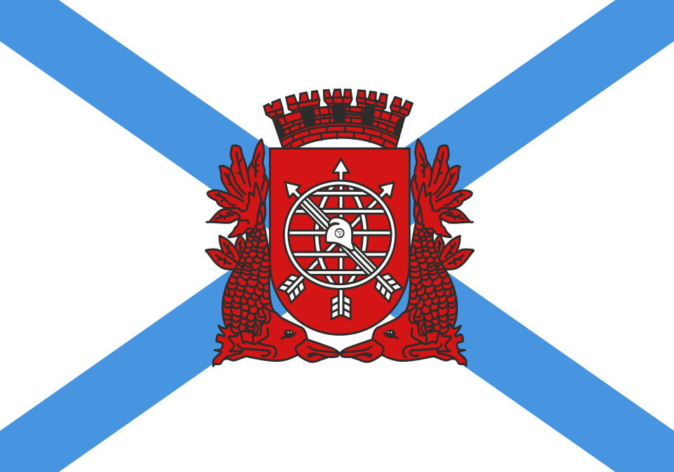
Rio de Janeiro at a glance
- Name
- Rio de Janeiro
- Country
- Brazil
- Profile type
- City
- Portuguese town foundation
- 1565
- Capital of the Vice-Kingdom
- From 1763
- Arrival of the Portuguese Royal Family
- 1808
- Brazilian Independence
- 1822
- End as a National Capital
- 1960
- Bay
- Guanabara Bay
- World Heritage Site of the Carioca Landscapes
- 2012
- Forest area
- Tijuca forest
- Mountain with Christ Figure
- Corcovado’
The Flag of Rio de Janeiro
The broad blue cross runs diagonally from corner to corner over the white cloth. In its center is the city coat of arms. This creates four white fields between the cross arms. For reliable recognition, the diagonal cross and the central coat of arms are crucial, not only the frequently used color combination of blue and white.
The version shown is a city flag and not a simplified landscape sketch. Their heraldic elements have a different function than tourist views of sugarloaf or Christ figure. Without a robust historical derivation, the individual colors should not be assigned to specific beaches or mountains; in the quiz, the testable visible form is first sufficient.
Rio de Janeiro: Location and Territorial Role
Rio de Janeiro is located on the Atlantic coast of Brazil and is the capital of the state of Rio de Janeiro. City and state are different levels of administration, even if they bear the same name. The current capital of Brazil is Brasília; Rio’s former role as a national capital, on the other hand, belongs to its particular historical importance.
The topography connects coastal plains with steep mountains and forest areas. On the Guanabara Bay and on the beaches facing the open sea, different urban landscapes are created. The UNESCO entry recognises selected parts of this cooperation. It refers to a specific cultural landscape and does not mean that every part of the entire urban area is equally registered as a World Heritage site.
Landscape, History and Culture
The Portuguese town was founded in 1565. In 1763, Rio became the capital of the Brazilian viceroyalty. With the arrival of the Portuguese royal family in 1808, the place received a new position within the monarchy. This sequence explains why the city’s history is closely intertwined with the political history of the whole of Brazil.
After independence in 1822, Rio remained a political center of the Empire and later of the Republic. The function as a national capital ended in 1960 with the inauguration of Brasília. Historical government buildings in Rio are therefore testimonies to a former state role and not automatically the seat of the current Brazilian federal government.
UNESCO included the Carioca landscapes between mountain and sea in the World Heritage List in 2012. Recognition includes not only natural forms, but also human-designed spaces and their relationships. Forest areas, viewpoints, gardens and coastal areas illustrate how urban development and an exceptional geographical starting point influenced each other.
Tijuca forest
The Tijuca forest forms a central part of the recognized landscape. Its importance is also close to densely built districts. Here it can be understood that an urban natural heritage does not necessarily lie outside the big city, but can directly influence its shape, its gaze relationships and its everyday perception.
Corcovado’
The Corcovado with the figure of Christ is a well-known motif of Rio. In the context of the cultural landscape, however, not only the statue is important, but also the mountain as a viewpoint and part of the city silhouette. The relationship between height, bay and development explains the special effect of many views of the city.
Copacabana
The Copacabana coast is one of the designed urban spaces where the sea and the big city come together immediately. The beach and promenade are part of a culturally shaped landscape. This view expands the idea of a mere seaside resort: public space, movement, architecture and the shape of the coast form a common urban context.
Explore this country and nearby profiles
 Brazil
 São Paulo
What did you discover?
Take this flag into the quiz
Sources and image credits
This English article draws on the institutional sources listed below. Figures and memberships retain their stated reference dates.
Source record: 2 November 2026. A translation does not change the reference date of a figure or membership list.
- whc.unesco.org/en/list/1100
- riotur.prefeitura.rio/por-dentro-do-rio/
- multirio.rj.gov.br/index.php/estude/historia-do-brasil/rio-de-janeiro/3351-muitos-janeiros
- gov.br/g20/pt-br/sobre-o-g20/cidades-sede/rio-de-janeiro-rj
- commons.wikimedia.org/wiki/File%3ABandeira_da_cidade_do_Rio_de_Janeiro.svg