Sierra Leone Flag, Capital and Country Facts
Sierra Leone is located on the West African Atlantic coast between Guinea and Liberia. Freetown is the capital and port city, while the inland area is shaped by hills, forests and eastern mountains. The history of the capital is closely linked to liberated and free-born people of African origin; the Gola-Tiwai natural heritage opens up another important context of the country.
Test your knowledge →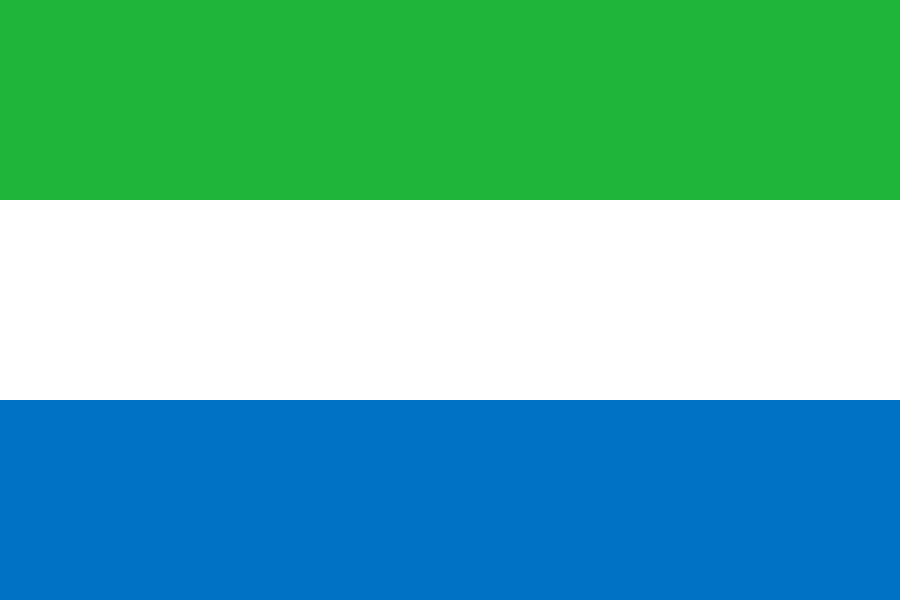
Sierra Leone at a glance
- Capital
- Freetown
- Quiz continent
- Africa
- Languages in reference record
- English (official language); Krio is an important linguistic language, including Mende and Temne
- Currency
- Sierra Leone (SLE)
- Population
- 8,819,794 (2025, World Bank)
- Area
- 71,740 km²
- Coastal setting
- Not landlocked
- ISO codes
- SL / SLE
- Internet country suffix
- .sl
- Highest mountain
- Bintumani / Loma Mansa, 1.948 m
- Independence
- 27 April 1961
- World Heritage Inspection
- Gola-Tiwai, 2025
- Important language of transport
- Krio
- Coastal Sea
- Atlantic Ocean
- Nature site
- Tiwai Island and Gola Rainforest
Sierra Leone Flag: Design, Meaning and History
The flag consists of three equally high horizontal stripes in green, white and blue. There is no coat of arms, no star and no sidebar. The blue lower stripe is a handy reminder: the color sequence differs from green-white-red or blue-white-green flags of other states, although individual colors match.
Green is associated with agriculture, mountains and natural resources, white with unity and justice. Blue stands for the sea and the natural harbor of Freetown. The symbolism thus combines a general reference to the landscape with a very concrete place; the port is important both on the map and in the color explanation.
Capital: Freetown
Freetown is located on a peninsula on the Atlantic coast and has a large natural harbour. Its name means Free City. The origin story is related to settlement projects for free and liberated people from enslavement. The name is therefore a historical reference and not any English city designation without connection to the country's history.
The capital is characterised by hills and coastal areas. Its function as a port and political centre distinguishes it from the inland regions further east. For spatial understanding, the narrow capital region should not be representative of all landscapes in the country: rainforests, agricultural areas and higher mountain ranges lie in other parts.
Practise this capital →Sierra Leone: Geography, History and Culture
A coastal band with mangroves merges into wooded hill country and plateaus. Mountains rise to the east; Bintumani and Loma Mansa reach 1,948 meters. The tropical climate has pronounced rainy and dry seasons. Precipitation and relief affect rivers, vegetation and traffic conditions, so that the coast and inland highlands have different environmental conditions.
The Gola Tiwai complex was added to the UNESCO World Heritage List in 2025. It connects the Gola Rainforest National Park with the protected area of Tiwai Island. The entry shows the international importance of remaining forest ecosystems in West Africa. It is a natural site and not a historical urban complex, although Sierra Leone also has an important cultural heritage.
English is an official language; Krio serves as a common language for many people. Mende and Temne belong to other important languages. Linguistic diversity shows different regional and historical links. Independence from Britain took place on 27 April 1961; this date is celebrated as a national holiday and complements Freetown’s older founding history.
Gola Tiwai since 2025
The UNESCO site comprises several sub-areas within two shelters. Forest and river island belong together, although they have different ecological conditions. The dated recording year is important because older country overviews can still perform Sierra Leone without a registered World Heritage site.
A port in the flag blue
The lower strip is explicitly associated with the sea and Freetowns harbor. This linkage turns a general meaning of colour into a concrete geographical note: the capital is located on the Atlantic Ocean and owes an important part of its importance to its port location.
Krio as a connection
A language of communication enables communication between people with different first languages. Krio fulfills such a role alongside the official use of English. Language in everyday life and the language of administration are therefore related, but not completely congruent categories.
Explore neighbouring and related places
 Guinea
 Liberia
What did you discover?
Sources and image credits
This English article draws on the institutional sources listed below. Figures and memberships retain their stated reference dates.
Source record: 2 November 2026. A translation does not change the reference date of a figure or membership list.
- github.com/factbook/factbook.json/blob/144d6977b2b01ac1cbd220de754c0a005616760b/africa/sl.json
- data.worldbank.org/indicator/SP.POP.TOTL
- whc.unesco.org/en/list/1746/
- github.com/mledoze/countries