Nepal Flag, Capital and Country Facts
Nepal lies between India and China on the southern edge of the Himalayas. The world’s only non-rectangular national flag matches a country with unusually high elevation differences. From the flat terai to the highest mountains on earth, landscape and climate change in a short distance. Kathmandu combines a densely populated valley with important religious and artisanal traditions.
Test your knowledge →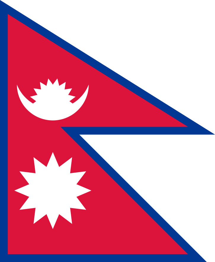
Nepal at a glance
- Capital
- Kathmandu
- Quiz continent
- Asia
- Languages in reference record
- Nepali as an official language; numerous other national languages
- Currency
- Nepali Rupee (NPR)
- Population
- 29,618,118 (2025, World Bank)
- Area
- 147,181 km²
- Coastal setting
- Landlocked
- ISO codes
- NP / NPL
- Internet country suffix
- .np
- Highest mountain
- Mount Everest, about 8,849 m
- Southern Plain
- Terai
- Time zone
- UTC+5:45
- Republic since
- 2008
- Religious site
- Lumbini
- Significant earthquake
- 2015
Nepal Flag: Design, Meaning and History
The flag consists of two red triangular pennants with a blue border arranged one above the other. In the upper part is a white moon symbol, in the lower part a white sun. It does not have a rectangular background field; the free contour of the two triangles is the actual flag shape. Especially this silhouette makes Nepal immediately recognizable even without detailed knowledge.
Red is associated, among other things, with rhododendron and bravery, blue with peace. Sun and moon belong to older rule and image traditions. Its current stylized form was established in 1962. Historical variants featured faces in the celestial bodies; the national flag depicted here does not use these faces. Popular interpretations of the triangles are to be distinguished from the precisely defined geometric construction.
Capital: Kathmandu
Kathmandu is located in a high-altitude basin in the central part of the country. The capital is thus neither a city of the southern lowlands nor a place of settlement directly on Mount Everest. The valley forms its own cultural and economic space. Its location linked historical trade routes between the Indian subcontinent and Tibet.
The UNESCO World Heritage Kathmandu Valley comprises several monument areas and not just a single square. These include palace complexes as well as Hindu and Buddhist sanctuaries. The city and its neighbouring towns suffered severe damage in the 2015 earthquake. Reconstruction therefore affects living religious and urban places, not only isolated museum buildings.
Practise this capital →Nepal: Geography, History and Culture
To the south lies the flat Terai as part of the North Indian deep plain landscape. North are followed by hill country and finally the High Himalayas. Mount Everest reaches about 8,849 meters and is located on the border with China. The same state thus contains tropical lowlands and extremely cold high mountain ranges; altitude is an essential climate factor. These landscape levels each have their own agricultural possibilities and natural limits of settlement.
Nepali is an official language, but the population speaks many other languages, including Maithili, Bhojpuri, Tamang and Nepalbhasha. The diversity is related to different historical settlement areas. Hindu and Buddhist traditions meet in many places, without this resulting in an identical religious practice for all people.
Nepal has historically been united as a kingdom and has been a republic since 2008. The factbook archive stand from 2025 describes a landlocked country with difficult mountain connections. Tourism is visible, but agriculture, migration and remittances are also important for the bigger picture. The well-known summits alone therefore explain neither the everyday life of the cities nor the economic conditions in remote valleys.
Sagarmatha
Sagarmatha National Park is a UNESCO World Heritage Site and includes the Everest region. The Nepalese name reminds us that internationally known mountains also have local names.
Chitwan
Chitwan National Park is also a World Heritage Site. Its lowland landscape is in clear contrast to the high-alpine Everest region.
Lumbini
Lumbini is UNESCO World Heritage Site as the birthplace of Buddha. The site is located in the southern lowlands and complements the often mountain-centered image of Nepal.
Explore neighbouring and related places
 China
 India
What did you discover?
Sources and image credits
This English article draws on the institutional sources listed below. Figures and memberships retain their stated reference dates.
Source record: 2 November 2026. A translation does not change the reference date of a figure or membership list.
- github.com/factbook/factbook.json/blob/144d6977b2b01ac1cbd220de754c0a005616760b/south-asia/np.json
- data.worldbank.org/indicator/SP.POP.TOTL
- whc.unesco.org/en/statesparties/np
- github.com/mledoze/countries