Morocco Flag, Capital and Country Facts
Morocco is located in northwestern Africa on the Atlantic and Mediterranean. Coastal plains, the Rif and the high chains of the Atlas form very different landscapes. Its red flag carries a green line star. Rabat is the capital, while Fès, Marrakesh and Meknès embody other historical centres of power and culture.
Test your knowledge →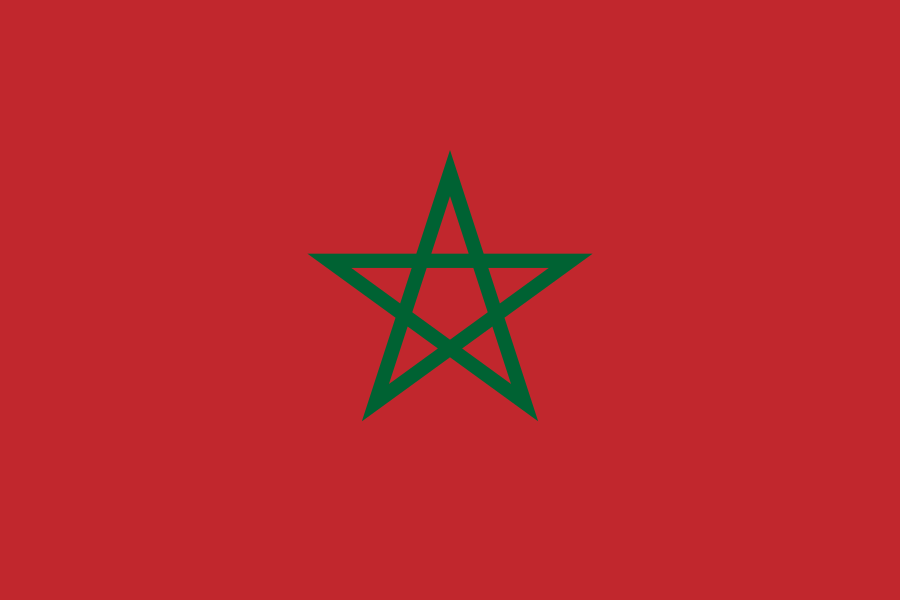
Morocco at a glance
- Capital
- Rabat
- Quiz continent
- Africa
- Languages in reference record
- Arabic and Amazigh; French spread in public life
- Currency
- Moroccan Dirham (MAD)
- Population
- 38,430,770 (2025, World Bank)
- Area
- 446,550 km²
- Coastal setting
- Not landlocked
- ISO codes
- MA / MAR
- Internet country suffix
- .ma, المغرب.
- Highest mountain range
- High Atlas
- Highest mountain
- Toubkal, around 4,167 m
- River at Rabat
- Bou Regreg
- Independence Year
- 1956
- Flag change
- Green Star since 1915
- Archaeological site
- Volubilis
Morocco Flag: Design, Meaning and History
The flag has a red field and in its center a green five-pointed line star. The five lines form an intertwined pentagram, not a filled star. A crescent moon is missing. This simple motif distinguishes Morocco from Tunisia’s white disc or from flags with several green stars.
The green star was added to the older red flag field in 1915. This confirms a current presentation of the state portal Maroc.ma and corrects differently dated short information in the archive material. Red is associated with the historical ruling tradition; the green star is often referred to as Solomon’s Seal. The flag became the symbol of the later independent kingdom.
Capital: Rabat
Rabat is located on the Atlantic coast at the mouth of Bou Regreg. On the opposite side is Salé. The capital has both older fortified urban areas and a modern, planned administrative city. This connection explains the UNESCO title, which explicitly names modern capital and historical urban fabric together.
Rabat can be distinguished from Casablanca, the large economic and port area further south. Even the historic royal cities are not today's replacement capitals. The juxtaposition of different centers helps to understand Morocco’s history: political power, trade, religious education and modern administration were not in the same place in every epoch.
Practise this capital →Morocco: Geography, History and Culture
The Rif characterizes the north, the Atlas Mountains divide large parts of the interior. High altitude, distance from the sea and distribution of precipitation generate strong regional differences. The Toubkal in the High Atlas reaches more than 4,000 meters. The idea of an exclusively hot desert country therefore misses both the mountain areas and the more fertile coastal plains. The Strait of Gibraltar separates the north of the country from Spain. It also connects the Mediterranean and the Atlantic. Morocco’s coasts thus belong to two different seas, although they meet at the same continental vertex.
Arabic and Amazigh are official languages. Moroccan Arabic, various Amazigh languages and French have different everyday functions. This multilingualism reflects older regional traditions as well as colonial history and international connections. No single language or design explains the entire population and all landscapes equally.
Independence from the French protectorate was achieved in 1956; at the same time, the kingdom has a much older state tradition. The UNESCO list offers concrete historical anchors: Roman remains in Volubilis, the medinae of several cities and Portuguese-influenced facilities in El Jadida. Additional geographical indications come from the factbook archive status of 2025 and are not used as a current political border decision.
Rabat as a World Heritage Site
Rabat was inscribed as a modern capital and historical city in 2012. This protects the interaction of different development phases.
Fès and Marrakesh
Both medinas have their own UNESCO registrations. They point to different historical cities and should not be described as interchangeable backdrops.
Volubilis
The archaeological site Volubilis is a World Heritage Site. It complements the medieval cityscapes with an important testimony of the Roman era.
Explore neighbouring and related places
 Algeria
 Spain
What did you discover?
Sources and image credits
This English article draws on the institutional sources listed below. Figures and memberships retain their stated reference dates.
Source record: 2 November 2026. A translation does not change the reference date of a figure or membership list.
- github.com/factbook/factbook.json/blob/144d6977b2b01ac1cbd220de754c0a005616760b/africa/mo.json
- data.worldbank.org/indicator/SP.POP.TOTL
- whc.unesco.org/en/statesparties/ma
- maroc.ma/fr/actualites/lhistoire-des-drapeaux-du-maroc-mise-en-avant-rabat
- visitmorocco.com/de/entdecken-sie-marokko/geographie-marokkos
- github.com/mledoze/countries