Mongolia Flag, Capital and Country Facts
Mongolia is a large landlocked country between Russia and China. Wide steppes, high mountains and the Gobi characterize different parts of the country. Ulaanbaatar is the capital and the most important urban centre of gravity; outside this area, great distances and mobile forms of pasture farming make the importance of landscape, seasons and transport routes particularly clear.
Test your knowledge →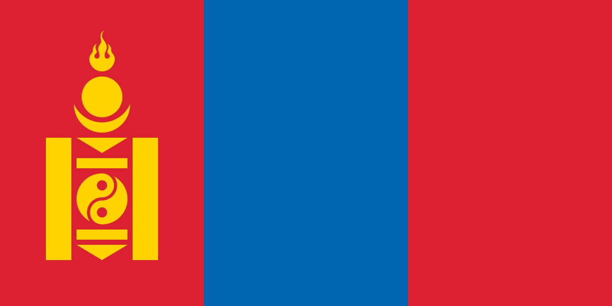
Mongolia at a glance
- Capital
- Ulaanbaatar
- Quiz continent
- Asia
- Languages in reference record
- Mongolian; also, among others, Kazakh in the West
- Currency
- Mongolian Tögrög (MNT)
- Population
- 3,568,978 (2025, World Bank)
- Area
- 1,564,110 km²
- Coastal setting
- Landlocked
- ISO codes
- MN / MNG
- Internet country suffix
- .mn
- Neighbouring countries
- Russia and China
- Highest mountain
- Khüiten, 4,374 m according to the archive
- Large Southern Landscape
- Gobi
- Capital river
- Tuul
- Traditional form of housing
- Ger/Yurt
- Flag signs
- Sojombo’
Mongolia Flag: Design, Meaning and History
The flag has three vertical stripes in red, blue and red. In the red stripe on the mast is the golden yellow Sojombo sign. So the symbol does not belong in the blue middle. This lateral position is a particularly useful clue if the flag is seen only small or from a greater distance.
The Sojombo combines abstract elements such as fire, sun, moon and other forms. Blue is associated with the sky, red among other things with development and prosperity. The sign has its own cultural history; it is neither an ordinary star nor a heraldic animal and should be recognized as a coherent symbol when learning.
Capital: Ulaanbaatar
Ulaanbaatar is located in the Tuul Valley and is the most important political and economic centre of the country. The German spelling Ulan Bator also encounters; the quiz data use Ulaanbaatar. Different transcriptions here mean the same city. Her name is translated as a red hero and refers to the political history of the 20th century.
The capital is located high inland and has a distinctly continental climate. Large differences between summer and winter match the distance from balancing sea surfaces. The strong contrast between the densely built-up city and large rural areas is essential for the country's image: Mongolia is not exclusively a landscape without large urban centers.
Practise this capital →Mongolia: Geography, History and Culture
In the west and north, high mountains rise, while steppes and dry landscapes determine large other spaces. The Khüiten in the Altai reaches 4,374 meters according to the Factbook archive. The Gobi in the south is not a continuous area of sand; rock, gravel and steppe spaces also belong to this large landscape and expand the widespread desert image.
Pasture farming with mobile use of large areas has a long history. The yurt, Mongolian ger, is a transportable form of living associated with such ways of life. However, one should not derive from this a uniform presence of all inhabitants: urban life, mining, services and different rural forms of economy coexist and change the settlement areas.
UNESCO runs, among others, the Orchon Valley, Karakorum-related historical landscapes, the petroglyphs of the Mongolian Altai and cross-border natural areas. The Orchon Valley shows the long connection between nomadic pasture use, trade and centers of domination. Mobility and fixed political places were thus historically no irreconcilable contradictions.
Orchon valley
The cultural landscape documents various historical epochs and the significance of the steppe as an exchange space. Fixed centers and long-range pasture use complement each other; the World Heritage therefore helps to avoid a too simple counterpart of nomads and cities.
Sojombo on the mast
The golden symbol is on the left red stripe. Those who learn their position recognize the flag even when individual details are hardly visible; the blue center remains free of a central coat of arms in the motif shown.
Gobi see differentiated
The dry landscape covers more than dunes. Different surfaces and transitions to steppes explain why photographs of different Gobi regions can look very different. The name denotes a larger natural area and not a single sandbox on the map.
Explore neighbouring and related places
 China
 Russia
What did you discover?
Sources and image credits
This English article draws on the institutional sources listed below. Figures and memberships retain their stated reference dates.
Source record: 2 November 2026. A translation does not change the reference date of a figure or membership list.
- github.com/factbook/factbook.json/blob/144d6977b2b01ac1cbd220de754c0a005616760b/east-n-southeast-asia/mg.json
- data.worldbank.org/indicator/SP.POP.TOTL
- whc.unesco.org/en/statesparties/mn/
- github.com/mledoze/countries