Ireland Flag, Capital and Country Facts
Ireland designates both an island and the state that occupies its largest part. Northern Ireland is part of the United Kingdom. The capital Dublin is on the east coast. Gentle inland landscapes, a strongly divided Atlantic coast and important prehistoric sites characterize the country, whose green-white-orange flag has a very different color sequence than Italy's tricolor.
Test your knowledge →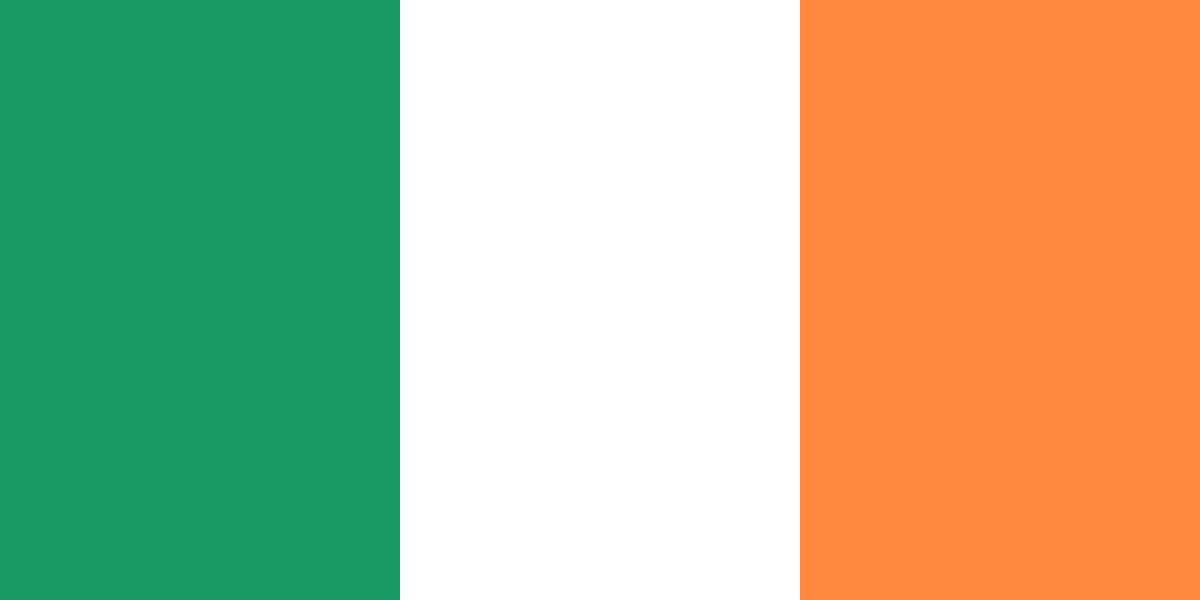
Ireland at a glance
- Capital
- Dublin
- Quiz continent
- Europe
- Languages in reference record
- Irish and English
- Currency
- Euro (EUR)
- Population
- 5,484,367 (2025, World Bank)
- Area
- 70,273 km²
- Coastal setting
- Not landlocked
- ISO codes
- IE / IRL
- Internet country suffix
- .ie
- Highest mountain
- Carrauntoohil, 1,039 m
- Significant river
- Shannon
- Capital river
- Liffey
- National holiday
- 17 March
- Archaeological installation
- Newgrange
- Sea in Dublin
- Irish Sea
Ireland Flag: Design, Meaning and History
The flag consists of three equally wide vertical stripes: green on the hoist side, white in the middle and orange at the fly edge. It does not contain a coat of arms. Orange should not be simplified to red when learning, because this difference separates the Irish flag from the Italian flag.
The tricolor became known in the 19th century as a sign of political understanding. A common interpretation combines green with the Irish national tradition, orange with the Protestant orange tradition and white with peace between them. This is a historical political reading, not a statement that all the people of the country could clearly be assigned to one of the two color groups.
Capital: Dublin
Dublin is located at the mouth of the Liffey in the Irish Sea. The capital is the political, economic and cultural center of the state. The coastal situation facilitated connections to Great Britain and other regions. Their Irish name Baile Átha Cliath and the English name derived from “dark pond” refer to different historical layers of names.
The city is a good starting point for distinguishing state and geographical terms: Dublin is the capital of Ireland, Belfast the capital of Northern Ireland. Both cities are located on the same island, but belong to different political units. Population figures and areas should therefore also indicate whether the state or the entire island is meant.
Practise this capital →Ireland: Geography, History and Culture
The interior is mostly flat to hilly, while higher areas are more often located on the edges. The Carrauntoohil reaches 1,039 meters. The Shannon is an important water axis with several lakes. In the west, bays, peninsulas and islands create a strongly divided Atlantic coastline, which differs significantly from the conditions around Dublin on the east coast.
Irish is one of the Celtic languages and has an official status alongside English. The daily use is very different regionally; the Gaeltacht areas are particularly important for this. English dominates many everyday areas. This distinction between legal status and actual use is more helpful than assuming that both languages are spoken to the same extent everywhere.
The prehistoric sites of Brú na Bóinne are located north of Dublin on the Boyne. Newgrange, Knowth and Dowth are large burial mounds with significant megalithic art. UNESCO describes an entire ritual and burial landscape, not just a single monument. It makes it clear that Ireland’s history begins long before medieval monasteries, British rule and the emergence of today’s state.
Burial mound at the Boyne
Brú na Bóinne has been a UNESCO World Heritage Site since 1993. The three main complexes Newgrange, Knowth and Dowth belong to a larger archaeological context.
A state on a divided island
The Irish state does not include the entire island. Northern Ireland is part of the United Kingdom and has Belfast as its capital.
Two official languages
Irish and English have official status. However, their use in everyday life is unevenly distributed over regions and areas of life.
Explore neighbouring and related places
 United Kingdom
Cities and regions in this country
 Dublin
What did you discover?
Sources and image credits
This English article draws on the institutional sources listed below. Figures and memberships retain their stated reference dates.
Source record: 2 November 2026. A translation does not change the reference date of a figure or membership list.
- github.com/factbook/factbook.json/blob/144d6977b2b01ac1cbd220de754c0a005616760b/europe/ei.json
- data.worldbank.org/indicator/SP.POP.TOTL
- whc.unesco.org/en/list/659
- github.com/mledoze/countries