Dublin: City Flag, History and Identity
Dublin is located on the Liffey and is the capital of Ireland. The city connects archaeological traces of the Viking Age with later administrative buildings, bridges and large parklands. Its flag unites a golden harp with three castles. In this way, it brings together national and urban signs without the exact historical significance of each castle being clearly clarified.
Test your knowledge →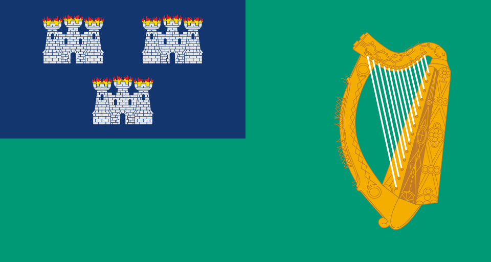
Dublin at a glance
- Name
- Dublin
- Country
- Ireland
- Profile type
- City
- Urban river
- Liffey
- Well-known pedestrian bridge
- Ha’penny Bridge
- Bridge construction
- 1816
- Bridge material
- Cast iron
- Viking phase
- First establishment from 841
- Renewed Viking Settlement
- 917
- Phoenix Park
- 1662 was created
- Parking area
- About 707 hectares
The Flag of Dublin
The flag shown has a green background with a large golden harp. In the blue upper corner on the hoist side stand three white castles, two arranged above one. The castles have small flame representations. This combination distinguishes the communal flag from both the Irish tricolor and other green flags with harp.
According to the official municipal publication, the flag has been used since 1885. The harp is in the national Irish context, the three castles belong to the local heraldry. Its original meaning is not surely handed down. Explanations as city gates, external watchtowers or triple representation of Dublin Castle are therefore possibilities and should not be told as a proven history of origin.
Dublin: Location and Territorial Role
Dublin is located in the east of Ireland on the Liffey. The river divides central urban areas and is spanned by numerous bridges. The Ha’penny Bridge is one of the most famous transitions. When looking at Dublin, one should distinguish between the administered city, the larger contiguous settlement space and the historic county; these spaces are not congruent.
The historic core is closely related to Dublin Castle and the former “black pond” to which the name Dubh Linn refers. Archaeological finds open up older settlement layers under today's construction. The visible urban space is therefore only a part of history: for some epochs excavations and museum collections provide more important evidence than still standing buildings.
Landscape, History and Culture
The Liffey is at the same time traffic space and orientation line. Built in 1816, the Ha’penny Bridge was built as a cast-iron pedestrian bridge. Its common name is reminiscent of the former bridge fee. The fact that it is still used today combines the history of new building materials and urban infrastructure with an everyday movement through the city centre from one shore to another.
The Vikings settled in the area of Dublin since 841. After an interruption, a new phase began in 917, in which the settlement developed into a city. This differentiated time sequence is more helpful than a single flat-rate founding year. It also shows that early urban development was characterised by trade, power changes and control of favourable water locations.
The Phoenix Park complements the dense city center with a large historical parkland. It was built in 1662 and covers about 707 hectares. In addition to recreation, it houses state institutions and the zoo. The combination of different uses makes it clear that a large city park is not only undeveloped green, but itself a historically organized space.
Ha’penny Bridge
The bridge spans the Liffey as a single flat arch. The state architectural monuments directory describes their cast iron construction as technically remarkable for the time of its creation. As a foot connection, it is both an everyday and a symbolic place. The comparison of material, form and use explains their meaning better than the well-known nickname alone.
Dublin Castle and older layers
In the surroundings of the castle, the older settlement history becomes particularly tangible. However, the Viking Age cannot simply be viewed as an unchanged streetscape. Archaeological investigations and historical mediation complement the visible buildings. Whoever combines both, recognizes Dublin as a city in which many epochs are spatially superimposed and differently well preserved.
Phoenix Park
The large parking area has its own history since the 17th century. Among other things, the residence of the President and the zoo are located within the area. This mix of public recreation, landscape and institutional uses distinguishes the park from a simple green space and complements the perception of Dublin with an expansive space west of the narrower centre.
Explore this country and nearby profiles
 Ireland
What did you discover?
Take this flag into the quiz
Sources and image credits
This English article draws on the institutional sources listed below. Figures and memberships retain their stated reference dates.
Source record: 2 November 2026. A translation does not change the reference date of a figure or membership list.
- dublincity.ie/sites/default/files/2025-06/18588_dcco_cityhall_coatofarms_6pp_dl_v7.pdf
- buildingsofireland.ie/buildings-search/building/50060550/hapenny-bridge-liffey-bridge-dublin-dublin-city
- dublincity.ie/dublin-city-parks-strategy/4-resources-and-services/41-parks/412-flagship-parks
- vikingeskibsmuseet.dk/en/professions/education/the-viking-age-geography/the-vikings-in-the-west/ireland/the-city-of-dublin
- commons.wikimedia.org/wiki/File%3AIRL_Dublin_flag.svg