Timor-Leste Flag, Capital and Country Facts
Timor-Leste is located in the eastern part of the island of Timor in Southeast Asia. The state also includes the exclave Oecusse and smaller islands such as Atauro. The capital Dili is located on the north coast. Mountain relief, several languages and the history of Portuguese colonial times and Indonesian occupation characterize a country whose independence was restored in 2002.
Test your knowledge →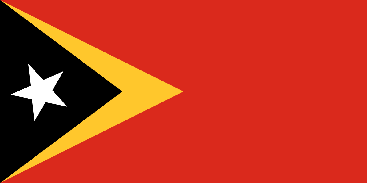
Timor-Leste at a glance
- Capital
- Dili
- Quiz continent
- Asia
- Languages in reference record
- Tetum and Portuguese as official languages; other local languages
- Currency
- US dollar (USD)
- Population
- 1,418,517 (2025, World Bank)
- Area
- 14,874 km²
- Coastal setting
- Not landlocked
- ISO codes
- TL / TLS
- Internet country suffix
- .tl
- Highest mountain
- Tatamailau, 2,963 m
- Restoration of independence
- 20 May 2002
- Declaration of Independence
- 28 November 1975
- Exclave
- Oecusse
- Island north of Dili
- Atauro
- Island group
- Small Sunda Islands
Timor-Leste Flag: Design, Meaning and History
On a red background there are two triangles starting from the left edge. The longer yellow triangle extends to approximately the center of the flag; above it lies a shorter black triangle. In this black field stands a white five-pointed star. The flag resembles Guyana’s flag in the direction of the arrow, but has neither green ground nor white and black dividing edges around the same surfaces.
The constitution explicitly explains the symbolism: yellow reminds of the colonial past, black of the ignorance to be overcome and red of the liberation struggle. The white star stands for peace and orientation. The motives thus refer to historical experiences and political goals. They are not to be understood as a judgmental description of today's population groups.
Capital: Dili
Dili is located on the north coast of East Timor. The capital is an administrative centre and an important coastal town with connections via the Wetar road. Behind the narrow coastal area, the terrain rises. Urban development must therefore deal with limited flat areas and the run-offs from the mountainous hinterland.
Atauro is located north of Dili and is a visible reference point above the sea in clear weather. The exclave Oecusse, on the other hand, is located further west on Timor's north coast and is separated from the rest of the country by Indonesia. Capital, offshore island and exclave illustrate three different forms of spatial division of the same state.
Practise this capital →Timor-Leste: Geography, History and Culture
Timor is one of the Little Sunda Islands. The interior is heavily mountainous; the Tatamailau reaches 2,963 meters. Coastal areas and higher areas differ in temperature and agricultural possibilities. Dry and rainy seasons affect water supply and accessibility. Short distances on the map can mean elaborate traffic routes in the mountains.
Tetum and Portuguese are official languages, and many other local languages are spoken. This diversity reflects different regional histories. The Portuguese language refers to the colonial period, but at the same time is part of today’s international relations. The belonging to Southeast Asia and the Portuguese-speaking connections thus describe different levels of the same national history.
A declaration of independence took place on November 28, 1975, shortly before the Indonesian invasion. After occupation, a process supported by the United Nations and transitional administration, independence was restored on 20 May 2002. The two national holidays therefore remind of different steps. A single year without explanation would not sufficiently represent the eventful emergence of the present state.
Separate oecusse
The exclave is located on the same island as the main part of the state. Nevertheless, the land route leads there through Indonesian territory.
Constitutional flag signs
The state symbol description mentions the meaning of triangles and star. Here, the color symbolism is therefore more officially anchored than with many other national flags.
Mountains in the interior of the island
Tatamailau is the highest mountain in the country. Its elevation difference from the coast makes the different natural conditions visible in a narrow space.
Explore neighbouring and related places
 Indonesia
What did you discover?
Sources and image credits
This English article draws on the institutional sources listed below. Figures and memberships retain their stated reference dates.
Source record: 2 November 2026. A translation does not change the reference date of a figure or membership list.
- github.com/factbook/factbook.json/blob/144d6977b2b01ac1cbd220de754c0a005616760b/east-n-southeast-asia/tt.json
- data.worldbank.org/indicator/SP.POP.TOTL
- timor-leste.gov.tl/
- github.com/mledoze/countries