Sri Lanka Flag, Capital and Country Facts
Sri Lanka is located in the Indian Ocean southeast of India. Coastal plains, a higher mountain country and historical irrigation landscapes characterize the island. For the capital, accuracy is important: Sri Jayewardenepura Kotte is the seat of parliament and the quiz-led capital, while neighboring Colombo continues to bundle important state institutions, trade and the large port.
Test your knowledge →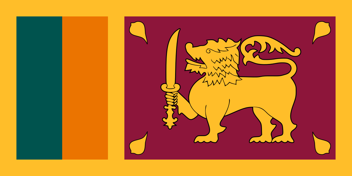
Sri Lanka at a glance
- Legislative capital
- Sri Jayewardenepura Kotte
- Quiz continent
- Asia
- Languages in reference record
- Sinhalese and Tamil; English as a connecting language
- Currency
- Sri Lankan Rupee (LKR)
- Population
- 21,756,000 (2025, World Bank)
- Area
- 65,610 km²
- Coastal setting
- Not landlocked
- ISO codes
- LK / LKA
- Internet country suffix
- .lk, .இலங்கை, .ලංකා
- Highest mountain
- Pidurutalagala, 2,524 m
- Independence
- 4 February 1948
- State name of Sri Lanka since
- 1972
- Parliament seat
- Sri Jayewardenepura Kotte
- Large commercial centre
- Colombo
- Dividing waters with India
- Palkstraße
Sri Lanka Flag: Design, Meaning and History
Parliament is based in Sri Jayewardenepura Kotte. Colombo is the commercial centre.
The flag has a golden yellow border and two different indoor fields. On the left are a green and an orange vertical stripe. On the right is a golden lion with a sword; in the four corners are golden leaves. These leaves belong to the bodhi tree and are not ordinary stars.
The lion is based on Sinhalese symbolic traditions, the sword stands for sovereignty. Green and orange are associated with Muslim and Tamil communities respectively. The bodhi tree leaves have a Buddhist reference. The motif thus combines different historical and religious signs; it should not be understood as a complete reflection of the diverse society today.
Legislative capital: Sri Jayewardenepura Kotte
Sri Jayewardenepura Kotte is located slightly inland in the greater Colombo area. Parliament is located there in its own building complex in a water landscape. The official parliament confirms Kotte as its location. For a learning side, the term seat of parliament is particularly meaningful because it designates a concrete function.
Colombo remains an important economic center and hosts other government tasks. Therefore, reference works often perform both places with different capital functions. The answer Kotte is correct in the quiz, but does not mean a complete loss of meaning Colombos. Political functions are distributed here over a contiguous urban space instead of two far apart parts of the country.
Practise this capital →Sri Lanka: Geography, History and Culture
The island is separated from the Indian mainland by the Palk Road and the Gulf of Mannar. Inside, the central highlands rise; Pidurutalagala reaches 2,524 meters. Rivers flow from the heights to different coastal directions. High altitude and monsoon winds produce regional differences in temperature and precipitation that affect agriculture and settlement.
Sinhala and Tamil are official languages, and English is an important link. Buddhist, Hindu, Muslim and Christian traditions are part of history. Ancient royal cities and irrigation facilities show how closely dominion, religion and water management were linked. The country can therefore be reduced neither to its beaches nor to a single language or religious community.
Sri Lanka became independent of Great Britain in 1948 under the name Ceylon and received its current state name in 1972. Tea plantations in the highlands refer to colonial economic structures and the history of their workforce. A long civil war ended in 2009; its consequences are part of recent history. The presentation focuses on robust geographical and historical contexts and does not incorporate current government data from the 2025 archive.
Parliament in the water area
The Parliament complex is located in Sri Jayewardenepura Kotte. Its location makes the institutional distinction to the nearby Colombo spatially comprehensible.
Highlands and coast
There are clear climate differences between the central mountains and the sea. The tea regions in the highlands therefore have different natural conditions than the coastal plains.
More than a name
Ceylon is the older state name, Sri Lanka which has been used since 1972. The old name continues to be encountered in historical documents and product names.
Explore neighbouring and related places
 India
What did you discover?
Sources and image credits
This English article draws on the institutional sources listed below. Figures and memberships retain their stated reference dates.
Source record: 2 November 2026. A translation does not change the reference date of a figure or membership list.
- github.com/factbook/factbook.json/blob/144d6977b2b01ac1cbd220de754c0a005616760b/south-asia/ce.json
- data.worldbank.org/indicator/SP.POP.TOTL
- parliament.lk/en/visit-parliament/visiting-parliament/how-to-get-here
- github.com/mledoze/countries