San Marino Flag, Capital and Country Facts
San Marino lies entirely within Italy on the edge of the Apennines. The small state does not have its own marine access, although the Adriatic coast is not far away. Its capital of the same name rises on Monte Titano. The white and light blue flag features three towers and the motto Libertas, which commemorates the republican independence of the country.
Test your knowledge →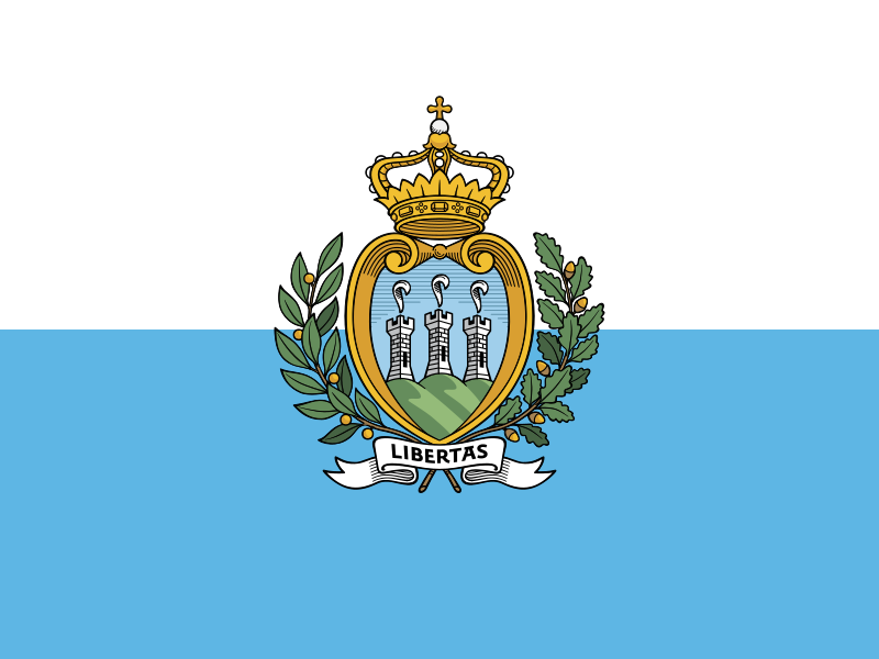
San Marino at a glance
- Capital
- San Marino
- Quiz continent
- Europe
- Languages in reference record
- Italian
- Currency
- Euro (EUR)
- Population
- 34,109 (2025, World Bank)
- Area
- 61 km²
- Coastal setting
- Landlocked
- ISO codes
- SM / SMR
- Internet country suffix
- .sm
- Highest point
- Monte Titano, 739 m
- Municipalities
- Nine Castelli
- Single neighbour
- Italy
- Coats of arms
- Guaita, Cesta and Montale
- Motto
- Libertas – Freedom
- World Heritage Site since
- 2008
San Marino Flag: Design, Meaning and History
The flag consists of two horizontal fields of equal height: white above and light blue below. In the middle is the state coat of arms with three towers on three mountain peaks. A branch wreath surrounds the shield; above it stands a crown, including the scroll with the word Libertas. The coat of arms is crucial for safe recognition.
The three towers stand for Guaita, Cesta and Montale on Monte Titano. The Latin motto means freedom and fits the historical emphasis on state independence. The crown in the coat of arms must not be understood as evidence of a present-day monarchy: San Marino is a republic. Heraldry and the current form of government must be explicitly distinguished here.
Capital: San Marino
The city of San Marino is located on the hillside and on the heights of Monte Titano. It is the capital of the state of the same name. Because country and city bear the same name, the precise formulation is worthwhile: not the entire territory forms a single city, but the capital is one of several municipalities.
The historic center and the Monte Titano were jointly UNESCO World Heritage sites in 2008. The entry links urban buildings, fortifications and their mountain location. Borgo Maggiore at the foot of the mountain and Serravalle further north are other settlement areas. The capital is thus a political and historical center within a structured, albeit very small, area of land.
Practise this capital →San Marino: Geography, History and Culture
The Monte Titano reaches 739 meters and shapes the silhouette of the country. The terrain is hilly to mountainous, although San Marino is near the Adriatic coastal plain. Short distances therefore connect very different elevations. The exposed location of the capital explains both historical defense possibilities and the widely visible towers that recur in the coat of arms.
Italy completely surrounds the state and is its only neighbour. San Marino is located as an enclave in the Italian territory, but has its own institutions. The proximity to the Italian region of Emilia-Romagna and to the brands explains close transport and economic connections. A lack of its own airport or port does not change the state autonomy; infrastructure can be reached via the surrounding neighbouring area.
Italian is the central language, the euro the means of payment used. San Marino is not part of the European Union. Its historical tradition traces its foundation to St. Marinus in 301; this early dating is to be marked as a founding tradition. The demonstrable development of medieval institutions and the later republic offers a different, more tangible historical approach.
Three towers
Guaita, Cesta and Montale give the coat of arms its most striking motif. They connect an abstract state symbol directly with real buildings on Monte Titano.
Nine Castelli
The municipalities are called Castelli and should not be confused with nine independent castle states. The term denotes the internal structure of the Republic.
The Republican Tradition
San Marino emphasizes a long history of political independence. The motto Libertas summarizes this claim without every detail of the founding legend being historically proven.
Explore neighbouring and related places
 Italy
What did you discover?
Sources and image credits
This English article draws on the institutional sources listed below. Figures and memberships retain their stated reference dates.
Source record: 2 November 2026. A translation does not change the reference date of a figure or membership list.
- github.com/factbook/factbook.json/blob/144d6977b2b01ac1cbd220de754c0a005616760b/europe/sm.json
- data.worldbank.org/indicator/SP.POP.TOTL
- whc.unesco.org/en/statesparties/sm/
- github.com/mledoze/countries