Papua New Guinea Flag, Capital and Country Facts
Papua New Guinea includes the eastern part of the island of New Guinea and numerous other islands in the western Pacific. High mountains, large rivers and coastal areas contribute to an exceptional linguistic diversity. The flag connects a bird of paradise with the Southern Cross. Port Moresby is located on the south coast and is only a part of this widely divided island world.
Test your knowledge →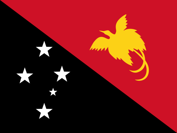
Papua New Guinea at a glance
- Capital
- Port Moresby
- Quiz continent
- Oceania
- Languages in reference record
- Tok Pisin, English, Hiri Motu; many other national languages
- Currency
- Kina (PGK)
- Population
- 10,762,817 (2025, World Bank)
- Area
- 462,840 km²
- Coastal setting
- Not landlocked
- ISO codes
- PG / PNG
- Internet country suffix
- .pg
- Highest mountain
- Mount Wilhelm, 4.509 m
- Independence
- 16 September 1975
- Divided main island
- New Guinea with Indonesia
- Large river
- Separation
- Another large island
- New Britain
- World Heritage Site
- Knuk
Papua New Guinea Flag: Design, Meaning and History
The flag is divided diagonally from top left to bottom right. The upper right triangle is red and bears a yellow flying bird of paradise. The lower left triangle is black; in it stand five white stars as the cross of the south. The diagonal and the large bird help distinguish them from other Pacific star flags.
Red, black and yellow are associated with traditional color schemes. The bird of paradise refers to the native wildlife and local cultural meanings. The Southern Cross symbolically places the country in the Southern Pacific. The flag was adopted in 1971, predating the independence of 1975.
Capital: Port Moresby
Port Moresby is located on the south coast of the mainland on the Gulf of Papua. The port location was named after a British seafaring family. As a capital, the city combines political and economic functions. However, the surrounding landscape cannot be equated with all other regions; especially the heavily rained highland valleys have different climatic conditions.
The central mountains make connections between the capital, the north coast and the highlands difficult. Air transport therefore plays an important role alongside local roads and ship connections. On a map neighboring places can be far apart in everyday life. The capital city location on the coast thus explains both its access to the sea and its limited connection over land.
Practise this capital →Papua New Guinea: Geography, History and Culture
New Guinea's mountain range extends largely from west to east. Papua New Guinea shares the large island with Indonesia, whose territory lies to the west. Mount Wilhelm reaches 4,509 meters. In addition, islands such as New Britain and New Ireland belong to the state. It is therefore not the entire island of New Guinea and not just a single continental part.
Tok Pisin is an important linguistic language; English and Hiri Motu fulfill other functions. There are also many local languages. The exact number depends on linguistic boundaries, which is why a seemingly unchangeable total number would be misleading. Mountains, island distances and independent community histories help to understand this diversity geographically.
Independence took place on 16 September 1975 after Australian administration. In the factbook archive stand of 2025, agriculture, mining and energy projects are important economic sectors. However, historical agriculture is not a mere antithesis to modern development: the Kuk archaeological site occupies independent agricultural traditions in the highlands and extends the view beyond colonial history.
Knuk
The early agricultural site Kuk is a UNESCO World Heritage Site. It documents a long history of landscape use in the New Guinean highlands.
Paradise birds
The yellow bird on the flag refers to a particularly well-known group of animals in the region. The motif combines nature and cultural significance.
Pacific ring of fire
The state is located in the area of the Pacific ring of fire. Volcanism and earthquakes are therefore important natural hazards, especially in some island regions.
Explore neighbouring and related places
 Indonesia
What did you discover?
Sources and image credits
This English article draws on the institutional sources listed below. Figures and memberships retain their stated reference dates.
Source record: 2 November 2026. A translation does not change the reference date of a figure or membership list.
- github.com/factbook/factbook.json/blob/144d6977b2b01ac1cbd220de754c0a005616760b/east-n-southeast-asia/pp.json
- data.worldbank.org/indicator/SP.POP.TOTL
- whc.unesco.org/en/statesparties/pg
- github.com/mledoze/countries