Gambia Flag, Capital and Country Facts
The Gambia is a narrow state along the river of the same name in West Africa. Except for the Atlantic coast, it is surrounded by Senegal. The long drawn country form is explained by the history of river trade and colonial borders. The capital is Banjul at the estuary; the river itself is a central point of reference for geography, traffic and even the flag.
Test your knowledge →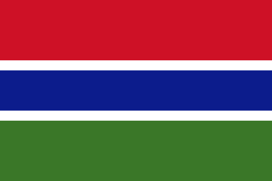
Gambia at a glance
- Capital
- Banjul
- Quiz continent
- Africa
- Languages in reference record
- English as an official language; among others Mandinka, Wolof and Fula
- Currency
- Gambian Dalasi (GMD)
- Population
- 2,822,093 (2025, World Bank)
- Area
- 10,689 km²
- Coastal setting
- Not landlocked
- ISO codes
- GM / GMB
- Internet country suffix
- .gm
- Independence
- 18 February 1965
- National holiday
- 18 February
- Former capital name
- Bathurst
- Name of Banjul since
- 1973
- Single neighbour
- Senegal
- Historical Island
- Kunta Kinteh Island
Gambia Flag: Design, Meaning and History
At the top is a red stripe, at the bottom a green stripe; between them runs a blue stripe with narrow white dividing lines. The flag does not carry a coat of arms or a star. In recognition, therefore, it is crucial that blue lies in the middle and is separated by white from the other two bold colors.
Blue stands for the Gambia River, green for vegetation and agriculture and red for sun and savannah. The white stripes are associated with peace and unity. Introduced in 1965 for independence, the flag thus shows a direct geographical connection: the river lies as a blue band between the landscape colors, similar to its central role in the country.
Capital: Banjul
Banjul is located on St. Mary’s Island at the mouth of the Gambia River into the Atlantic Ocean. The place was called Bathurst in the British colonial period and received its current name in 1973. The location at the transition between sea and river explains the historical importance as a port and administrative center.
The capital cannot be equated with the entire metropolitan area. Serekunda and other places are located outside their narrow urban area and are important for the settlement structure. If you only consider a population of Banjul, you can therefore underestimate the size of the urban space. Political capital, communal boundaries and related development are different geographical categories.
Practise this capital →Gambia: Geography, History and Culture
The land consists mainly of the river plain and adjacent low terrain. It has no great high mountains; even the highest elevations remain very low. Towards the estuary, tides and salt water influence the landscape. Further inland, shore vegetation and uses change, although the entire state appears on the map like a narrow corridor.
The Gambia River originates outside the territory of Guinea and also passes through Senegal. Its catchment area thus transcends political boundaries. English is an official language, while Mandinka, Wolof, Fula and other languages are important in everyday life. The current state border therefore does not completely separate the river or cultural and linguistic connections from the neighbouring regions.
Independence from Britain was achieved on 18 February 1965. Kunta Kinteh Island and related sites commemorate the long history of African-European contacts and the Atlantic slave trade. UNESCO emphasizes the control of the hinterland over the river. The historical heritage is therefore closely linked to the same waterway, which still today makes the conspicuous form of government understandable.
Places of remembrance on the river
Kunta Kinteh Island and associated sites have been on the UNESCO World Heritage List since 2003. They document different phases of encounter and violence between Africa and Europe.
Almost completely surrounded by Senegal
Only the Atlantic opening interrupts the enclosure. The Gambia is therefore not a complete enclave and has its own marine access.
Flat country
The river plain shapes the landscape more than mountains. Small differences in altitude can nevertheless be decisive for flooding, agriculture and settlements.
Explore neighbouring and related places
 Senegal
What did you discover?
Sources and image credits
This English article draws on the institutional sources listed below. Figures and memberships retain their stated reference dates.
Source record: 2 November 2026. A translation does not change the reference date of a figure or membership list.
- github.com/factbook/factbook.json/blob/144d6977b2b01ac1cbd220de754c0a005616760b/africa/ga.json
- data.worldbank.org/indicator/SP.POP.TOTL
- whc.unesco.org/en/list/761
- github.com/mledoze/countries