Eswatini Flag, Capital and Country Facts
Eswatini is a small landlocked country in southern Africa between South Africa and Mozambique. Its flag carries a shield, spears and a decorated staff. Mbabane is the administrative capital, while Lobamba performs royal and parliamentary duties. Highlands, medium altitudes and warmer lowlands form different landscapes in a narrow space.
Test your knowledge →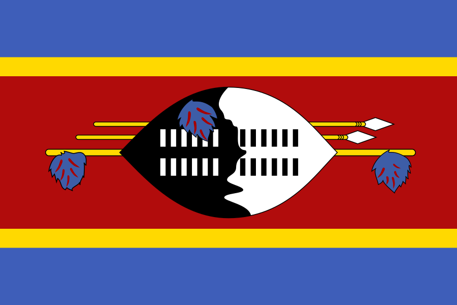
Eswatini at a glance
- Administrative centre
- Mbabane
- Quiz continent
- Africa
- Languages in reference record
- SiSwati and English
- Currency
- Lilangeni (SZL); South African Rand (ZAR) also in circulation
- Population
- 1,256,174 (2025, World Bank)
- Area
- 17,364 km²
- Coastal setting
- Landlocked
- ISO codes
- SZ / SWZ
- Internet country suffix
- .sz
- Highest mountain
- Emlembe, 1.862 m
- Independence
- 6 September 1968
- Change of name
- 2018 by Eswatini
- Royal and parliamentary seat
- Lobamba
- Eastern high altitude
- Lubombo’
- Historical mining site
- Ngwenya
Eswatini Flag: Design, Meaning and History
Mbabane is the administrative centre. Lobamba is the royal and legislative seat.
A wide red midfield lies between narrower blue border stripes. Yellow lines separate red and blue. In the middle lies a large black and white shield in front of two horizontal spears and a staff decorated with feathers. This concrete equipment motif distinguishes the flag from geometrical oblique cross or stripe flags of the region.
The design dates back to a military flag awarded in the Second World War and became the national flag in the context of independence. Blue is assigned to peace, red to historical struggles and yellow to mineral resources. Shield and weapons stand in the state interpretation for protection. Its image is a historical symbol and not a description of everyday life today.
Administrative centre: Mbabane
Mbabane is located in the western highlands and is the administrative seat of government. The quiz therefore uses Mbabane as the capital’s answer. The higher location leads to different climatic conditions than in the deeper eastern regions. Administration and services are concentrated here, while the rest of the country has different economic and political priorities.
Lobamba is the royal and legislative capital. There are central facilities of the Royal House and the Parliament. The regional community of states SADC expressly describes this division of tasks. Both places must be explained together, instead of dismissing a capital statement as wrong: they name different functions within the same state.
Practise this capital →Eswatini: Geography, History and Culture
From west to east, the terrain as a whole descends from the Highveld via the Middleveld to the Lowveld. On the eastern side is the Lubombo Höhenzug. The elevation levels affect temperatures, precipitation and agriculture. Despite its small size, Eswatini does not have a similar landscape everywhere. The Emlembe in the northwest is the highest mountain. The only two neighbours are South Africa and Mozambique. As a result, Eswatini does not have its own seaport; international goods routes rely on transit connections to ports in neighbouring states.
SiSwati and English are official languages. The political and cultural history is closely linked to the Swazi Kingdom. The state name was changed from Swaziland to Eswatini in 2018; older books therefore often still use the former name. The current name does not signify independence only at this time.
Independence from the United Kingdom was achieved on 6 September 1968. The factbook archive of 2025 mentions, among other things, the sugar industry, forestry and industry as economic sectors. South Africa is particularly important through neighbourhood and economic connections. The joint use of the edge next to the Lilangeni makes this interconnection immediately visible in everyday life.
Ngwenya mines
The Ngwenya mines are on the UNESCO proposal list. They document the long use of mineral resources, but are not yet a registered world heritage.
Dual capital function
Mbabane and Lobamba share administrative, royal and parliamentary tasks. This division is more important for a correct country description than the search for only one supposedly complete capital name.
Elevation levels
Highveld, Middleveld and Lowveld explain major regional differences. The landscape names describe high altitudes and not three independent states or capitals.
Explore neighbouring and related places
 Mozambique
 South Africa
What did you discover?
Sources and image credits
This English article draws on the institutional sources listed below. Figures and memberships retain their stated reference dates.
Source record: 2 November 2026. A translation does not change the reference date of a figure or membership list.
- github.com/factbook/factbook.json/blob/144d6977b2b01ac1cbd220de754c0a005616760b/africa/wz.json
- data.worldbank.org/indicator/SP.POP.TOTL
- whc.unesco.org/en/statesparties/sz
- sadc.int/member-states/kingdom-eswatini
- github.com/mledoze/countries