Oslo: City Flag, History and Identity
Oslo is located on the inner Oslofjord and is the capital of Norway. Port development, city fires and new cultural places have repeatedly changed the urban space. Today’s blue flag with the city seal combines a modern flag version with a much older motif. It is therefore a good example that the age of a symbol does not have to correspond to the age of its flag.
Test your knowledge →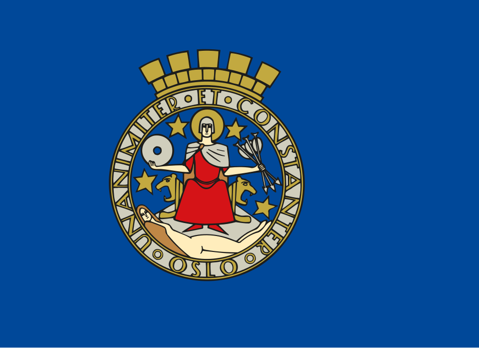
Oslo at a glance
- Name
- Oslo
- Country
- Norway
- Profile type
- City
- Situation on the water
- Inner Oslofjord
- Old port area
- Bjørvika
- Historical fortress
- Akershus
- Big city fire
- 1624
- Name of the new plant
- Christiania
- Trade flows
- Akerselva,
- Waterfront planning
- Fjordbyen Decision 2000
- Opera house opening
- 2008 in Bjørvika
The Flag of Oslo
The flag shown bears on a blue background the colored round city seal with an overhanging crown of the wall. In the middle sits St. Hallvard; his attributes include three arrows and a millstone. The detailed picture is expressly the blue version used since the anniversary year 2000 and not the older blue-and-white striped city flag.
The seal motif goes back to medieval models. His figures have been interpreted and drawn differently over time. The Hallvard legend connects arrows and millstone with his death; it is to be understood as a sacred tradition. The figure under his feet changed in later representations. A current picture version must therefore not be regarded as an unchanged copy of the medieval seal.
Oslo: Location and Territorial Role
Oslo is located in the southeast of Norway at the end of the Oslofjord. Bjørvika Bay is one of the oldest port areas in the city. The historical port location connects settlement, trade and access to the sea. For the understanding of the city center, it is important that central functions shifted over the centuries and that today's waterfront does not represent a single epoch.
After the great city fire of 1624, the town was moved closer to the Akershus fortress and rebuilt as Christiania. The older settlement area and the later urban complex can therefore be distinguished spatially. This shift explains why medieval city history, fortress space, and newer downtown do not simply coincide at the same point on today’s map.
Landscape, History and Culture
The Akerselva River was connected to sawmills and other commercial facilities. Timber was one of the port’s important export goods. As a result, the inner-city watercourses connected with the fjord and other trade routes. Today’s image of cultural houses and publicly accessible shores complements an older landscape of workshops, storage areas and freight traffic.
The port development changed with steam shipping and new technical requirements. Fixed quays and more efficient transhipment locations gained in importance. The municipal port company describes this story as a repeated expansion along the central waterfront. The port was thus not only a delimited basin, but a changing area that characterised large parts of the city shore.
In 2000, the City Council adopted the Plan Fjordbyen. It aimed to convert former port areas for new urban uses. The opera house in Bjørvika, which opened in 2008, is part of the modern cultural profile of this area. Oslo shows here particularly vividly how once hard-to-access traffic and work areas can receive new public functions within the city.
Bjørvika and Opera House
The Norwegian National Opera and the National Ballet received their new house in Bjørvika in 2008. The location is thus located in the middle of a historic harbour space. Cultural use is part of a larger change in the waterfront. If you compare older portscapes with today's surroundings, you can see how fundamentally the relationship between the city and the fjord has changed.
Akershus and the Relocation
The fortress explains a decisive turning point in the city's history: after the fire of 1624, the new city was built under its protection. This spatial context helps to distinguish Christiania from the older settlement. The city centre thus also emerged from a political decision that closely linked security, planning and reconstruction.
City seal on blue
The seal preserves many details that are hardly recognizable on a small flag. Arrows, millstone, Hallvard and the transcription belong to a historical picture program. The blue flag version from 2000 makes this older sign the focal point of a newer urban appearance and illustrates the separation between symbolic history and concrete flag form.
Explore this country and nearby profiles
 Norway
What did you discover?
Take this flag into the quiz
Sources and image credits
This English article draws on the institutional sources listed below. Figures and memberships retain their stated reference dates.
Source record: 2 November 2026. A translation does not change the reference date of a figure or membership list.
- oslohavn.no/en/menu/about-us/history---port-of-oslo/
- operaen.no/en/about-us-oslo-operahouse/
- snl.no/Oslos_flagg_og_v%C3%A5pen
- snl.no/Oslo_-_historie
- oslo.kommune.no/slik-bygger-vi-oslo/fjordbyen
- commons.wikimedia.org/wiki/File%3AFlag_of_Oslo.svg