Lyon: City Flag, History and Identity
Lyon is located at the confluence of Rhône and Saône in eastern France. Different neighbourhoods preserve the traces of antiquity, Renaissance, trade and textile production. Their flag connects the silver lion on red with three gold lilies on blue. Those who want to understand the city will find a particularly vivid historical cityscape between rivers, hills and hidden passageways.
Test your knowledge →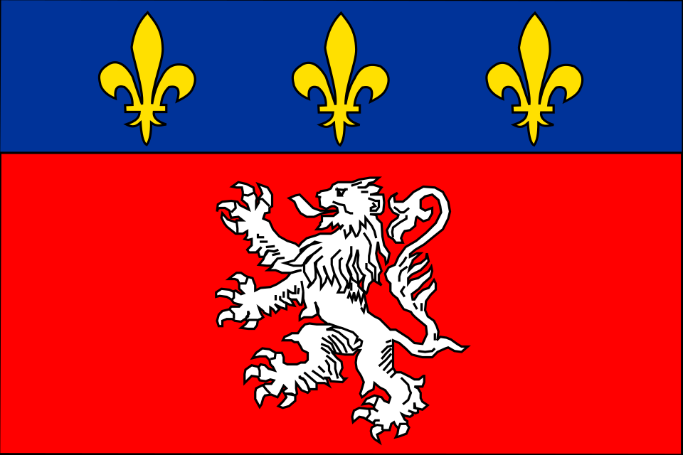
Lyon at a glance
- Name
- Lyon
- Country
- France
- Profile type
- City
- Collapse
- Rhône and Saône
- Peninsula
- Presqu’île
- Western hill
- Fourvière
- Textile history urban area
- Croix rousse
- Ancient name
- Lugdunum
- World Heritage Inspection
- 1998
- Historical passages
- Traboules
- Historical professional group
- Canuts, the Silk Workers
The Flag of Lyon
The flag shown is a flat implementation of the city coat of arms. In the large red field stands a white or silver lion. Above it lies a blue horizontal zone with three golden lilies. The blue field is therefore not an equally wide stripe of an ordinary tricolor, but the upper part of a coherent heraldic representation with a clear hierarchy of motifs.
The lion forms an easily noticeable linguistic reference between Lyon and the French word “lion”. However, it does not follow that the city name was originally derived from the animal: the ancient name is Lugdunum. The lilies belong to the context of French royal symbolism. The picture shown is reduced to the main characters without additional outer coat of arms and should be described exactly as such.
Lyon: Location and Territorial Role
Lyon is located at the confluence of Saône and Rhône. Between the rivers stretches the Presqu’île, the peninsula. Fourvière rises to the west; the Croix-Rousse forms another important hill area. This landscape explains the spatial differences between older neighbourhoods, shore zones and later expansions. The city’s history can therefore be particularly well accessed on the basis of its topography.
The UNESCO World Heritage Site encompasses more than the well-known Vieux Lyon. The historical zone also includes Fourvière, the slopes of Croix-Rousse and the northern part of the Presqu’île to Ainay. Protection thus refers to several contiguous urban spaces. A visit to only one quarter conveys an important section, but not yet the whole historical complex.
Landscape, History and Culture
The development gradually shifted eastward over the centuries. As a result, older quarters were preserved, while new functions and designs were created elsewhere. UNESCO emphasizes this continuity. Unlike a complete new building at the same place, different urban epochs in Lyon can be read next to each other and compared with each other.
Lugdunum was an important centre in Roman times. Later layers range from medieval alleys to Renaissance houses to the special living and working environment of the silk workers on Croix-Rousse. Since 1998, the historic Lyon has been a UNESCO World Heritage Site. The award thus concerns a long-term development of the urban fabric, not just a style or a single monument.
The Traboules are passageways that connect streets through buildings and courtyards. They create additional paths within densely built quarters. Their preservation requires at the same time consideration for the people living there and for private buildings. The city and metropolis support certain agreements through which such passages can be maintained and kept open to the public.
Vieux Lyon and Traboules
The passages open a second level of the city floor plan. Behind a street facade can be courtyards, stairs and other connections. Thus, the Traboules tell of everyday walks and the use of dense buildings. They should be understood as parts of inhabited buildings; their importance is not only to provide visitors with a surprising shortcut.
Fourvière and urban development
The hill is one of the central areas of the historical World Heritage site. From there, the relationship between altitudes, rivers and urban quarters can be traced. Particularly illuminating is the comparison with the more eastern areas: it makes visible the gradual spatial relocation of the city, which has contributed to the preservation of various historical layers.
Croix-Rousse and Presqu’île
The slopes of the Croix-Rousse preserve the memory of the living and working environment of the canuts, the silk workers. The Presqu’île shows in turn other forms of urban development between the rivers. Together with Vieux Lyon and Fourvière, both areas are part of the historical context. Their differences make it clear why Lyon is protected as a multi-layered urban landscape and not as a uniform old town image.
Explore this country and nearby profiles
 France
 Paris
 Marseille
What did you discover?
Take this flag into the quiz
Sources and image credits
This English article draws on the institutional sources listed below. Figures and memberships retain their stated reference dates.
Source record: 2 November 2026. A translation does not change the reference date of a figure or membership list.
- lyon.fr/sortir-et-decouvrir/decouvrir-lyon-et-son-patrimoine/le-site-historique-de-lyon-distingue-par
- whc.unesco.org/fr/list/872
- lyon.fr/vie-pratique/logement-et-urbanisme/la-renovation-des-batiments-classes-et-des-traboules
- visiterlyon.com/decouvrir/sites-et-monuments/renaissance/cours-et-traboules-du-vieux-lyon
- objetspol.inha.fr/s/objetspol/item/313
- commons.wikimedia.org/wiki/File%3AFlag_of_Lyon%2C_France.svg