Lesotho Flag, Capital and Country Facts
Lesotho is completely surrounded by South Africa and at the same time a distinct mountainous country. Its unusual location makes it easily recognizable on the map. On the flag stands a black Basotho hat between blue and green. The motif combines a concrete cultural object with the themes of rain, peace and prosperity.
Test your knowledge →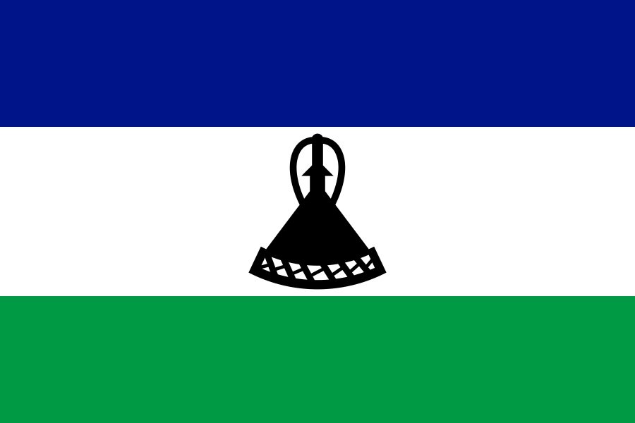
Lesotho at a glance
- Capital
- Maseru
- Quiz continent
- Africa
- Languages in reference record
- Sesotho and English
- Currency
- Loti (LSL); South African Rand also legal tender
- Population
- 2,363,325 (2025, World Bank)
- Area
- 30,355 km²
- Coastal setting
- Landlocked
- ISO codes
- LS / LSO
- Internet country suffix
- .ls
- Highest mountain
- Thabana Ntlenyana, 3,482 m
- Surrounding State
- South Africa
- River Maseru
- Caledon/Mohokare
- Independence
- 4 October 1966
- Flag signs
- Mokorotlo, traditional basotho hat
- World Heritage
- Maloti-Drakensberg Park
Lesotho Flag: Design, Meaning and History
The flag has three horizontal stripes in blue, white and green. In the wider white midrange lies the black silhouette of a traditional basotho hat, the Mokorotlo. The sign has a wide lower edge and an elevated, conical construction. It is neither a mountain nor a building and should be explicitly recognized as a hat when learning.
Today’s design was introduced in 2006 on the fortieth anniversary of independence. In the traditional declaration, blue stands for rain, white for peace and green for prosperity. The hat replaced earlier military symbols. In this way, the motif sets a different accent and uses an object connected with the cultural identity of the Basotho.
Capital: Maseru
Maseru is located on the western edge of the country near Caledon, which accompanies the border with South Africa. The capital thus has a border position and no location in the high eastern mountains. This position explains its transport links and its importance as an economic and administrative centre in a country strongly divided by differences in altitude.
The border separates states, but does not interrupt all economic and family connections. Lesotho’s situation in the middle of South Africa characterizes trade, labour migration and transport. Maseru makes this close neighbourhood particularly vivid. Despite this, Lesotho is an independent state and not a South African province; the complete enclosure is a geographical peculiarity, not an indication of a lack of independence.
Practise this capital →Lesotho: Geography, History and Culture
The whole country is high; large areas reach far beyond the heights of the surrounding South African plains. To the east are the Maloti and the Drakensbergs with deep valleys and high peaks. Snow is possible in the higher elevations. The example corrects the widespread simplification that African states must in principle be warm and tropical all year round.
Sesotho and English are official languages. The country name Lesotho and the name Basotho for the population belong together, but do not denote the same. Historical places of state formation and the memory of King Moshoeshoe I. complement the natural geography. UNESCO has had a corresponding group of sites on its list of proposals since 2025.
Maloti-Drakensberg Park is a joint World Heritage Site of Lesotho and South Africa. It is part of both cultural and natural heritage. The landscape includes mountain habitats and significant rock art. Here it is particularly clear that a state border can divide neither a mountain system nor the historical use of the landscape into two independent stories.
One state in another
Lesotho is completely surrounded by South Africa. This situation is called an enclave, without questioning its state independence.
Hat instead of coat of arms
The black Mokorotlo is the center of the flag. Its silhouette is a more precise learning feature than a general interpretation of the three colors.
Common mountain heritage
Maloti-Drakensberg Park connects Lesotho and South Africa. UNESCO recognizes both natural and cultural values of the area.
Explore neighbouring and related places
 South Africa
What did you discover?
Sources and image credits
This English article draws on the institutional sources listed below. Figures and memberships retain their stated reference dates.
Source record: 2 November 2026. A translation does not change the reference date of a figure or membership list.
- github.com/factbook/factbook.json/blob/144d6977b2b01ac1cbd220de754c0a005616760b/africa/lt.json
- data.worldbank.org/indicator/SP.POP.TOTL
- whc.unesco.org/en/statesparties/ls
- github.com/mledoze/countries